IMAGES TAKEN NEAR TO
Tatsfield Lane, WESTERHAM, TN16 2EQ
Introduction
This page details the photographs taken nearby to Tatsfield Lane, TN16 2EQ by members of the Geograph project.
The Geograph project started in 2005 with the aim of publishing, organising and preserving representative images for every square kilometre of Great Britain, Ireland and the Isle of Man.

There are currently over 7.5m images from over14,400 individuals and you can help contribute to the project by visiting https://www.geograph.org.uk
Image Map (Loading...)


Getting Data...Please wait
Leaflet Map data © OpenStreetMap
Images are licensed for reuse under creativecommons.org/licenses/by-sa/2.0
Notes
- Clicking on the map will re-center to the selected point.
- The higher the marker number, the further away the image location is from the centre of the postcode.
Image Listing (18 Images Found)
Images are licensed for reuse under creativecommons.org/licenses/by-sa/2.0
Image
Details
Distance
1
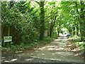
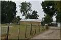
Palace Road
A dead-end off Chestnut Avenue.
Image: © Robin Webster
Taken: 31 Jul 2011
0.10 miles
2
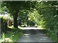
Tatsfield Lane, near Biggin Hill
Tatsfield Lane runs along the boundary between Kent and Greater London. The road itself is in Kent, but the land to the left of the road is in Greater London.
Image: © Malc McDonald
Taken: 21 Aug 2016
0.13 miles
3
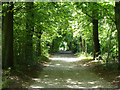
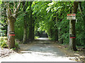
Chestnut Avenue
This eastern part is a private vehicle track but public bridleway.
Image: © Robin Webster
Taken: 31 Jul 2011
0.14 miles
4
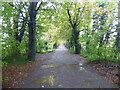
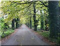
A wet day on Chestnut Avenue
Chestnut Avenue is a private driveway leading away from Hawley's Corner and Westerham Heights Garden Centre.
Image: © Marathon
Taken: 4 Oct 2020
0.15 miles
5
A wet day along Chestnut Avenue
Chestnut Avenue is a private driveway leading away from Hawley's Corner and Westerham Heights Garden Centre.
Image: © Marathon
Taken: 4 Oct 2020
0.16 miles
6
Chestnut Avenue
This eastern end is a private road but public bridleway.
Image: © Robin Webster
Taken: 31 Jul 2011
0.16 miles
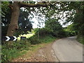
8
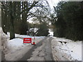
Closed Tatsfield Lane
As seen from close to Hawley's Corner.
A bridleway leads left along Chestnut Avenue, to the B2024 Clark's Lane.
Closed due to the ice on the road.
Image: © David Anstiss
Taken: 9 Dec 2010
0.19 miles
9
Chestnut Avenue
This eastern part is a private road but public bridleway.
Image: © Robin Webster
Taken: 31 Jul 2011
0.20 miles
10
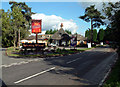
The Spinning Wheel at Hawley's Corner, TN16
At the end of Gray's Road, which leads west from the A223 Westerham Hill. In front of the restaurant-cum-pub is the private Spinning Wheel Cottage.
Image: © Philip Talmage
Taken: 20 Oct 2005
0.20 miles