IMAGES TAKEN NEAR TO
High Street, WESTERHAM, TN16 1LE
Introduction
This page details the photographs taken nearby to High Street, TN16 1LE by members of the Geograph project.
The Geograph project started in 2005 with the aim of publishing, organising and preserving representative images for every square kilometre of Great Britain, Ireland and the Isle of Man.

There are currently over 7.5m images from over14,400 individuals and you can help contribute to the project by visiting https://www.geograph.org.uk
Image Map (324 Images)


Getting Data...Please wait
Leaflet Map data © OpenStreetMap
Images are licensed for reuse under creativecommons.org/licenses/by-sa/2.0
Notes
- Clicking on the map will re-center to the selected point.
- The higher the marker number, the further away the image location is from the centre of the postcode.
Image Listing (324 Images Found)
Images are licensed for reuse under creativecommons.org/licenses/by-sa/2.0
Image
Details
Distance
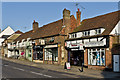
1
Shops on Market Square, Westerham, Kent
Image: © Oast House Archive
Taken: 29 Dec 2008
0.00 miles
4
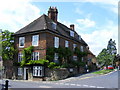
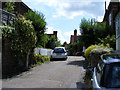
House at junction of High Street and Croydon Road Westerham
Image: © PAUL FARMER
Taken: 25 Jul 2009
0.01 miles
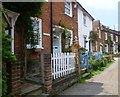
5
13 - 25a High Street
A row of cottages/shops/businesses on High Street.
Image: © Ian Capper
Taken: 25 Apr 2013
0.02 miles
6
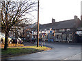
Lodge Lane, Westerham
This is Lodge Lane as it leads up to the High Street in Westerham.
Image: © Marathon
Taken: 7 Jul 2013
0.02 miles
7
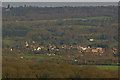
Westerham
A telephoto view from the North Downs Way below Clarks Lane.
Image: © Ian Capper
Taken: 15 Apr 2010
0.03 miles
8
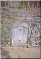
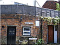
Old Milestone by the A25, High Street, Westerham Parish
Stone post (plate lost) by the A25, in parish of WESTERHAM (SEVENOAKS District), High Street, opposite Nos 2 - 4, near junction with Wells Place, set in wall by letterbox, on South side of road. Wrotham iron plate, erected by the Wrotham Heath turnpike trust in the 19th century.
Inscription once read:- : (MAIDSTONE / 21 / GODSTONE / 7½) :
Milestone Society National ID: KE_MDGS21.
Image: © C Woodward
Taken: 30 Apr 2007
0.04 miles
9
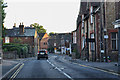
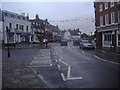
Westerham : High Street, A25
Looking along the Westerham High Street.
Image: © Lewis Clarke
Taken: 8 Aug 2015
0.04 miles