IMAGES TAKEN NEAR TO
Rectory Lane, WESTERHAM, TN16 1JP
Introduction
This page details the photographs taken nearby to Rectory Lane, TN16 1JP by members of the Geograph project.
The Geograph project started in 2005 with the aim of publishing, organising and preserving representative images for every square kilometre of Great Britain, Ireland and the Isle of Man.

There are currently over 7.5m images from over14,400 individuals and you can help contribute to the project by visiting https://www.geograph.org.uk
Image Map (Loading...)


Getting Data...Please wait
Leaflet Map data © OpenStreetMap
Images are licensed for reuse under creativecommons.org/licenses/by-sa/2.0
Notes
- Clicking on the map will re-center to the selected point.
- The higher the marker number, the further away the image location is from the centre of the postcode.
Image Listing (85 Images Found)
Images are licensed for reuse under creativecommons.org/licenses/by-sa/2.0
Image
Details
Distance
2
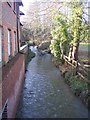
The River Darent
This river flows from Dartford to Sevenoaks and then through Brasted before ending in Westerham. Seen from Rectory Lane bridge.
Image: © David Anstiss
Taken: 17 Jan 2010
0.02 miles
3
Corner of High Street & Rectory Lane
What! no traffic! Had to wait a while for that.
Image: © Josie Campbell
Taken: 3 Jul 2013
0.03 miles
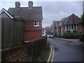
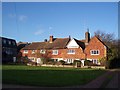
4
Houses on the village green at Brasted
The busy High Street (A25) is just to the right of the green in this otherwise rural looking scene.
Image: © Marathon
Taken: 7 Jul 2013
0.03 miles
5
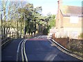
Rectory Lane bridge over the River Darent
This road leads from the A25 Brasted High Street towards Brasted Hill Road. Bridge Cottage is on the right.
Image: © David Anstiss
Taken: 17 Jan 2010
0.03 miles
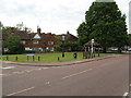
6
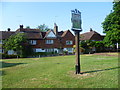
The village sign on the green at Brasted
The busy High Street (A25) is just behind me in this otherwise rural looking scene. For a close up of the village sign see http://www.geograph.org.uk/photo/3549565
Image: © Marathon
Taken: 7 Jul 2013
0.04 miles
7
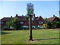
The village sign on the green at Brasted
The busy High Street (A25) is just behind me in this otherwise rural looking scene. For a close up of the village sign see http://www.geograph.org.uk/photo/3549565
Image: © Marathon
Taken: 7 Jul 2013
0.04 miles
8
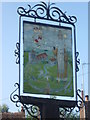
Close up of the village sign at Brasted
The River Darent and St Martin's Church both feature prominently in the sign on the village green at Brasted. For the setting see http://www.geograph.org.uk/photo/3549558
Image: © Marathon
Taken: 7 Jul 2013
0.04 miles
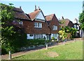
9
The Old Manor House
On the village Green at the junction of the A25 Brasted High Street (in front) and Rectory Lane (on the left).
Image: © David Anstiss
Taken: 17 Jan 2010
0.04 miles
10
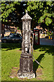
Pump on Brasted Green
19th century cast iron pump. Grade II listed - see www.historicengland.org.uk/listing/the-list/list-entry/1083907.
Image: © Ian Capper
Taken: 28 Jun 2012
0.04 miles