IMAGES TAKEN NEAR TO
High Street, WESTERHAM, TN16 1HL
Introduction
This page details the photographs taken nearby to High Street, TN16 1HL by members of the Geograph project.
The Geograph project started in 2005 with the aim of publishing, organising and preserving representative images for every square kilometre of Great Britain, Ireland and the Isle of Man.

There are currently over 7.5m images from over14,400 individuals and you can help contribute to the project by visiting https://www.geograph.org.uk
Image Map (Loading...)


Getting Data...Please wait
Leaflet Map data © OpenStreetMap
Images are licensed for reuse under creativecommons.org/licenses/by-sa/2.0
Notes
- Clicking on the map will re-center to the selected point.
- The higher the marker number, the further away the image location is from the centre of the postcode.
Image Listing (45 Images Found)
Images are licensed for reuse under creativecommons.org/licenses/by-sa/2.0
Image
Details
Distance
1
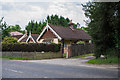
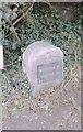
Heverswood Lodge
Former lodge on the western edge of Brasted. The drive alongside it once led to Heverswood, a large house on Chart Lane, but has since been truncated. On the right is the milestone in Image
Image: © Ian Capper
Taken: 20 Jun 2013
0.02 miles
2
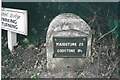
Old Milestone by A25, Westerham Road, by Heverswood Lodge, West edge of village
The Milestone is located beside gatepost on verge on the South of the road. Parish of Brasted (Sevenoaks District). Metal plate attached to stone post, Wrotham iron plate design, erected by the Wrotham Heath turnpike trust in the 19th Century. An earlier photograph can be found here: https://www.geograph.org.uk/photo/6099277
Inscription reads:-
MAIDSTONE / 20 / GODSTONE / 8½
Milestone Society National ID: KE_MDGS20
Image: © JR Dowding
Taken: 1 Jan 2023
0.03 miles
3
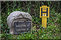
Milestone
Milestone on the route of the Wrotham Heath and Croydon and Godstone Road Turnpike originally built in the 1760s, now largely the A25. For photo of location see Image For other examples, both with a metal plate showing the distance to Maidstone and Godstone but of a different design from this one, see Image and Image See also Image for the next one to the east, which has lost its plate.
Image: © Ian Capper
Taken: 20 Jun 2013
0.03 miles
5
Old Milestone by the A25, Westerham Road, Brasted
Metal plate attached to stone post by the A25, in parish of Brasted (Sevenoaks District), Westerham Road, by Heverswood Lodge, West edge of village, beside gatepost on verge, on South side of road. Wrotham iron plate, erected by the Wrotham Heath turnpike trust in the 19th century.
Inscription reads:-
MAIDSTONE
20
GODSTONE
8½
Kent HER.
HER Number: TQ 45 SE 141 https://www.heritagegateway.org.uk/Gateway/Results_Single.aspx?uid=MKE78089&resourceID=1005
Milestone Society National ID: KE_MDGS20
Image: © C Woodward & JR Dowding
Taken: 30 Apr 2007
0.03 miles
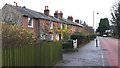
6
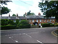
Cottages on High Street, Brasted
This view looks from the cul-de-sac known as West End across the very busy A25 during a rare break in the traffic. The A25 must have been horrendous before the M25 was built. It is bad enough now.
Image: © Marathon
Taken: 19 Aug 2013
0.04 miles
7
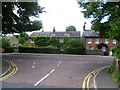
West End, Brasted
This view looks from the cul-de-sac known as West End across the very busy A25 during a rare break in the traffic. The A25 must have been horrendous before the M25 was built.
Image: © Marathon
Taken: 19 Aug 2013
0.04 miles
10
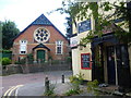
Chapel and disused pub in Brasted
The chapel on the far side of the busy A25 dates from 1886. The Stanhope Arms on the right was for sale at the time of this photograph, although the chalked notice next to the door was asking for kitchen and bar staff. This is the view from Church Lane.
Image: © Marathon
Taken: 19 Aug 2013
0.08 miles