IMAGES TAKEN NEAR TO
Ford Lane, SEVENOAKS, TN15 7SE
Introduction
This page details the photographs taken nearby to Ford Lane, TN15 7SE by members of the Geograph project.
The Geograph project started in 2005 with the aim of publishing, organising and preserving representative images for every square kilometre of Great Britain, Ireland and the Isle of Man.

There are currently over 7.5m images from over14,400 individuals and you can help contribute to the project by visiting https://www.geograph.org.uk
Image Map
Images are licensed for reuse under creativecommons.org/licenses/by-sa/2.0
Notes
- Clicking on the map will re-center to the selected point.
- The higher the marker number, the further away the image location is from the centre of the postcode.
Image Listing (25 Images Found)
Images are licensed for reuse under creativecommons.org/licenses/by-sa/2.0
Image
Details
Distance
1
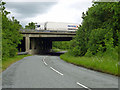
Ford Lane under the M26
The M26 is much used by continental freight traffic, even on a bank holiday.
Image: © Robin Webster
Taken: 4 Jun 2012
0.04 miles
2
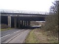
Ford Lane goes under M26 Motorway
Ford Lane leads to Trottiscliffe from Wrotham Heath. M26 Motorway goes over bridge heading right to join M20 motorway towards Maidstone, from M25 junction 5.
Image: © David Anstiss
Taken: 17 Feb 2009
0.05 miles

4
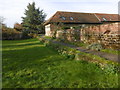
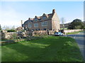
In front of Ford Place
Ford Place consists of one wing of a large Elizabethan or Jacobean mansion. According to John Newman in Pevsner's "The Buildings of England: West Kent and The Weald" the plan must have been a half-H of which the centre and north wing have disappeared. He points out that on the chimney stacks are the dates 1582 and 1605, although the numerals are 20th century.
This is the small green between the garden wall and the road. See also http://www.geograph.org.uk/photo/4903680
Image: © Marathon
Taken: 10 Apr 2016
0.05 miles
5
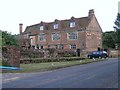
Ford Place, near Wrotham
Situated just south of where the M26 joins the M20, Ford Place is probably the oldest house in the area.
Image: © Hywel Williams
Taken: 3 Aug 2005
0.07 miles
6
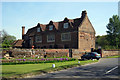
Ford Place from the north
Ford Place consists of one wing of a large Elizabethan or Jacobean mansion. According to John Newman in Pevsner's "The Buildings of England: West Kent and The Weald" the plan must have been a half-H of which the centre and north wing have disappeared. He points out that on the chimney stacks are the dates 1582 and 1605, although the numerals are 20th century. See also http://www.geograph.org.uk/photo/4903680
Image: © Marathon
Taken: 10 Apr 2016
0.08 miles
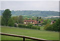
7
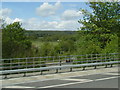
Landscape north of the M26 seen from Ford Lane bridge
Image: © Colin Pyle
Taken: 13 May 2013
0.09 miles
8
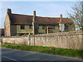
Ford Place, Ford Lane, Wrotham Heath
Grade II* Listed.
Image: © Oast House Archive
Taken: 22 Apr 2009
0.10 miles
9
Ford Place from the south
Ford Place consists of one wing of a large Elizabethan or Jacobean mansion. According to John Newman in Pevsner's "The Buildings of England: West Kent and The Weald" the plan must have been a half-H of which the centre and north wing have disappeared. He points out that on the chimney stacks are the dates 1582 and 1605, although the numerals are 20th century. For the view of the north side see http://www.geograph.org.uk/photo/4903682
Image: © Marathon
Taken: 10 Apr 2016
0.10 miles
10
Ford Place
Grade II* listed. http://www.britishlistedbuildings.co.uk/en-427268-ford-place-and-wall-to-north-addington-k
Image: © N Chadwick
Taken: 18 May 2013
0.10 miles