IMAGES TAKEN NEAR TO
Seven Mile Lane, SEVENOAKS, TN15 7SA
Introduction
This page details the photographs taken nearby to Seven Mile Lane, TN15 7SA by members of the Geograph project.
The Geograph project started in 2005 with the aim of publishing, organising and preserving representative images for every square kilometre of Great Britain, Ireland and the Isle of Man.

There are currently over 7.5m images from over14,400 individuals and you can help contribute to the project by visiting https://www.geograph.org.uk
Image Map
Images are licensed for reuse under creativecommons.org/licenses/by-sa/2.0
Notes
- Clicking on the map will re-center to the selected point.
- The higher the marker number, the further away the image location is from the centre of the postcode.
Image Listing (24 Images Found)
Images are licensed for reuse under creativecommons.org/licenses/by-sa/2.0
Image
Details
Distance
1
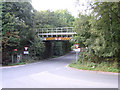
Railway bridge, Wrotham Heath, Kent
The B2016 Seven Mile Lane near its junction with Teston Road passes beneath the Otford–Maidstone East spur opened in 1874.
Image: © Rodney Burton
Taken: 9 Sep 2006
0.04 miles
2
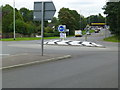
A new roundabout at Wrotham Heath
This is where the B2016 - Seven Mile Lane - joins the A26. It's a busy junction, I had a long wait before there were no cars negotiating it.
Image: © Ron Lee
Taken: 7 Sep 2015
0.09 miles
3

Seven Mile Lane
Not a typical lane, in fact it looks like a typical turnpike, with long straights taking a fairly direct course from the A25 at Wrotham Heath south to East Peckham, a distance that seems about the seven miles.
Image: © Robin Webster
Taken: 4 Jun 2012
0.10 miles
4

Old Milestone by the A20, London Road, Addington parish
Modern stone plaques attached to stone post by the A20, in parish of ADDINGTON (TONBRIDGE AND MALLING District), London Road, by "Sundown", near junction with Seven Mile Lane, back of verge beside wooden fence and gate, on North side of road. Kent hipped iron plate, erected by the Wrotham & Maidstone turnpike trust in the 19th century.
Inscription reads:-
: MAIDSTONE / 8 : : TO / LONDON / 26/ - / Addington : : WROTHAM / 2 :
Kent HER.
HER Number: TQ 65 NW 266 https://www.heritagegateway.org.uk/Gateway/Results_Single.aspx?uid=MKE78046&resourceID=1005
Milestone Society National ID: KE_LF26.
Image: © C Woodward
Taken: 10 Jun 2009
0.10 miles
5

Houses on Sandy Lane, Wrotham Heath
The porch is new, as is the white paint half way up the house.
Image: © David Howard
Taken: 17 Jul 2016
0.13 miles


8
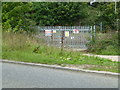
Teston Road Offham by the railway line
This gate is where there was once a level crossing to the A20. On the A20 side, where there is now a garage, there used to be an all-night transport cafe in a wooden building. They were there in 1956 but had gone by 1979.
Image: © Ron Lee
Taken: 7 Sep 2015
0.18 miles
9
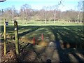
Small footbridge in golf course
Footpath No.MR154 leads through Wrotham Heath Golf course, from B2016 Seven Mile Lane to Valley Wood, and up to the Wealdway (long distance path).
Image: © David Anstiss
Taken: 2 Mar 2009
0.18 miles
10
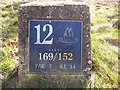
12th Tee Marker in Wrotham Heath Golf Course
Nice stone marker, showing badge of club.
Image: © David Anstiss
Taken: 2 Mar 2009
0.20 miles