IMAGES TAKEN NEAR TO
Shorehill Lane, SEVENOAKS, TN15 6XF
Introduction
This page details the photographs taken nearby to Shorehill Lane, TN15 6XF by members of the Geograph project.
The Geograph project started in 2005 with the aim of publishing, organising and preserving representative images for every square kilometre of Great Britain, Ireland and the Isle of Man.

There are currently over 7.5m images from over14,400 individuals and you can help contribute to the project by visiting https://www.geograph.org.uk
Image Map
Images are licensed for reuse under creativecommons.org/licenses/by-sa/2.0
Notes
- Clicking on the map will re-center to the selected point.
- The higher the marker number, the further away the image location is from the centre of the postcode.
Image Listing (12 Images Found)
Images are licensed for reuse under creativecommons.org/licenses/by-sa/2.0
Image
Details
Distance
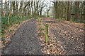
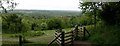
1
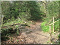
The North Downs Way crosses a footpath from Kemsing
The long distance footpath goes over steps towards Fabs Wood and then onto Wrotham via other woods and fields. It comes from Otford Mount, above Otford. The footpath going up the hill leads from Pilgrims Way, near Kemsing leading past Otford Manor to Clarkes Green Road.
Image: © David Anstiss
Taken: 15 Apr 2009
0.05 miles
2
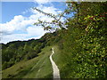
The scarp slope of the North Downs on Kemsing Down
This is above Kemsing as the footpath crosses the chalk downland of Kemsing Down - see https://www.kentwildlifetrust.org.uk/nature-reserves/kemsing-down
Image: © Marathon
Taken: 1 Sep 2019
0.05 miles
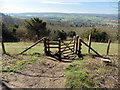
3
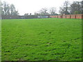
Otford Manor Unused Walled Garden
Large victorian walled garden just used as store for caravan and grass meadow. Seen from North Downs Way (a long distance path) that passes the Manor between Rowdow Wood and Fabs Wood.
Image: © David Anstiss
Taken: 15 Apr 2009
0.06 miles
5
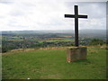
Cross on the downs above Kemsing
This simple wooden cross seems to be related to the nearby Christian Conference centre at Otford Manor.
Image: © Pip Rolls
Taken: 28 Aug 2006
0.15 miles
8
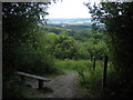
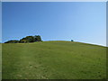
Whiteleaf Down on the North Downs Way
Whiteleaf Down is on the steep scarp slope of the North Downs. The fields and woods of the Weald of Kent can be seen in the distance.
Image: © Pip Rolls
Taken: 28 Aug 2006
0.23 miles
10
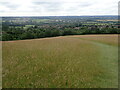
View from the North Downs above Kemsing
This is above the village of Kemsing. The Greensand Ridge can be seen beyond the valley.
Image: © Marathon
Taken: 11 Jul 2021
0.25 miles