IMAGES TAKEN NEAR TO
Seal Chart, SEVENOAKS, TN15 0ET
Introduction
This page details the photographs taken nearby to TN15 0ET by members of the Geograph project.
The Geograph project started in 2005 with the aim of publishing, organising and preserving representative images for every square kilometre of Great Britain, Ireland and the Isle of Man.

There are currently over 7.5m images from over14,400 individuals and you can help contribute to the project by visiting https://www.geograph.org.uk
Image Map
Images are licensed for reuse under creativecommons.org/licenses/by-sa/2.0
Notes
- Clicking on the map will re-center to the selected point.
- The higher the marker number, the further away the image location is from the centre of the postcode.
Image Listing (30 Images Found)
Images are licensed for reuse under creativecommons.org/licenses/by-sa/2.0
Image
Details
Distance
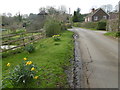
1
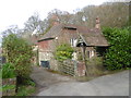
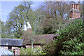
Styants Oast House
This is just after Styants Bottom Road emerges from Oldbury Wood. For more information about Styants Oast House see http://www.geograph.org.uk/photo/778750
Image: © Marathon
Taken: 10 Apr 2016
0.01 miles
3
Styants Oast House, Styants Bottom Road, Seal, Kent
Image: © Oast House Archive
Taken: 26 Apr 2008
0.02 miles
5
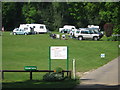
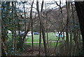
Olbury Hill Camping and Caravan Park
On Styants Bottom, close to Olbury Wood. Only members of The Camping and Caravan Club can use this site.
Image: © David Anstiss
Taken: 24 May 2009
0.03 miles
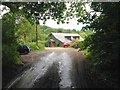
6
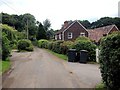
Styants Bottom near Oldbury
This is just after Styants Bottom Road emerges from Oldbury Wood and looks up to the hamlet of Styants Bottom.
Image: © Marathon
Taken: 10 Apr 2016
0.05 miles
7
Styants Bottom near Oldbury
This is just after Styants Bottom Road emerges from Oldbury Wood and looks up to the hamlet of Styants Bottom.
Image: © Marathon
Taken: 10 Apr 2016
0.06 miles
8
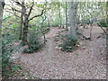
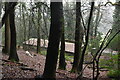
Path in Oldbury Woods up to the Iron Age fort on Oldbury Hill
The Iron Age fort on Oldbury Hill was built between 150 and 50 BC and covered about 124 acres. The ramparts had a circumference of about two and half miles. At the time this was a bare hillside crowned with earth ramparts and a strong wooden palisade. From the ramparts there would have been commanding views of the surrounding countryside. This was one of the most significant Iron Age hill forts on a major trading route.
It was not really a military structure in the usual sense as in times of peace it served as an administrative and commercial centre while most people lived on farms in the surrounding countryside. There was also a flourishing iron industry hereabouts. In times of trouble, though, it was a defensive position to which people could retreat with their cattle.
Image: © Marathon
Taken: 29 Oct 2016
0.08 miles