IMAGES TAKEN NEAR TO
Mill Lane, SEVENOAKS, TN14 7TP
Introduction
This page details the photographs taken nearby to Mill Lane, TN14 7TP by members of the Geograph project.
The Geograph project started in 2005 with the aim of publishing, organising and preserving representative images for every square kilometre of Great Britain, Ireland and the Isle of Man.

There are currently over 7.5m images from over14,400 individuals and you can help contribute to the project by visiting https://www.geograph.org.uk
Image Map
Images are licensed for reuse under creativecommons.org/licenses/by-sa/2.0
Notes
- Clicking on the map will re-center to the selected point.
- The higher the marker number, the further away the image location is from the centre of the postcode.
Image Listing (98 Images Found)
Images are licensed for reuse under creativecommons.org/licenses/by-sa/2.0
Image
Details
Distance
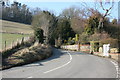
1
Oxbourne Farm seen from the Darent Valley Path
The Darent Valley Path is 19 miles (31 km) long, following the River Darent from Sevenoaks station through the Kent Downs Area of Outstanding Natural Beauty to the banks of the River Thames at Dartford.
The River Darent flows from its source in the Greensand hills, south of Westerham, to join the Thames, north of Dartford. The walk is through a varied landscape of riverside fringed with ancient willows, hop gardens and cornfields, secretive woodlands, downland carpeted with wild flowers and expanses of marshland and has the added attractions of Roman remains, majestic viaducts, historic houses, old mills and picturesque villages with beautiful churches. There is an alternative start point at Chipstead (TQ500561).
A description of the route is given at http://en.wikipedia.org/wiki/Darent_Valley_Path
Image: © N Chadwick
Taken: 17 Feb 2010
0.01 miles
4
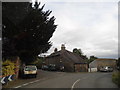
High Street at the junction of Mill Lane, Shoreham
Image: © David Howard
Taken: 30 Sep 2012
0.05 miles
5
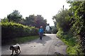
Lane in Shoreham
This lane leads down to Mill House and the River Darent (both behind the photographer).
Image: © Trevor Harris
Taken: 9 Aug 2009
0.05 miles
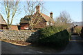
6
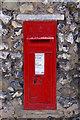
Victorian postbox
In a wall near the junction of Mill Lane and High Street.
Image: © Ian Capper
Taken: 8 May 2008
0.05 miles
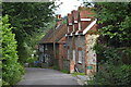
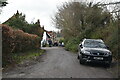
7
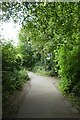
Mill Lane
Looking along Mill Lane in Shoreham from the Darent Valley path.
Image: © DS Pugh
Taken: 10 Jul 2023
0.05 miles
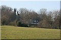
9

Darent Valley Path, Shoreham
The Darent Valley Path alongside the River Darent at Shoreham, Kent.
Image: © Malc McDonald
Taken: 15 Jan 2012
0.05 miles