IMAGES TAKEN NEAR TO
Burlings Lane, SEVENOAKS, TN14 7PD
Introduction
This page details the photographs taken nearby to Burlings Lane, TN14 7PD by members of the Geograph project.
The Geograph project started in 2005 with the aim of publishing, organising and preserving representative images for every square kilometre of Great Britain, Ireland and the Isle of Man.

There are currently over 7.5m images from over14,400 individuals and you can help contribute to the project by visiting https://www.geograph.org.uk
Image Map
Images are licensed for reuse under creativecommons.org/licenses/by-sa/2.0
Notes
- Clicking on the map will re-center to the selected point.
- The higher the marker number, the further away the image location is from the centre of the postcode.
Image Listing (18 Images Found)
Images are licensed for reuse under creativecommons.org/licenses/by-sa/2.0
Image
Details
Distance
4
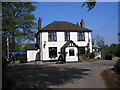
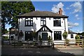
The 'Tally Ho', Knockholt, Kent
Excellent food and a choice of well-kept beers are on offer at this country 'local'.
Image: © Dr Neil Clifton
Taken: 11 May 2006
0.13 miles

6
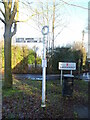
Direction Sign ? Signpost on Main Road, Knockholt
Located on a grass triangle in the centre of the junction of Burlings Lane and Main Road in Knockholt parish. 1 arm and annulus finial.
Milestone Society National ID: KE_TQ4558
Image: © John V Nicholls
Taken: 30 Dec 2012
0.14 miles
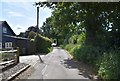
9
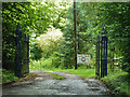
Gates to Wood Farm
Ornate iron gates and fence, but not too well founded - neither gatepost is anywhere near vertical.
Image: © Robin Webster
Taken: 27 Aug 2011
0.18 miles