IMAGES TAKEN NEAR TO
Main Road, SEVENOAKS, TN14 6EF
Introduction
This page details the photographs taken nearby to Main Road, TN14 6EF by members of the Geograph project.
The Geograph project started in 2005 with the aim of publishing, organising and preserving representative images for every square kilometre of Great Britain, Ireland and the Isle of Man.

There are currently over 7.5m images from over14,400 individuals and you can help contribute to the project by visiting https://www.geograph.org.uk
Image Map
Images are licensed for reuse under creativecommons.org/licenses/by-sa/2.0
Notes
- Clicking on the map will re-center to the selected point.
- The higher the marker number, the further away the image location is from the centre of the postcode.
Image Listing (13 Images Found)
Images are licensed for reuse under creativecommons.org/licenses/by-sa/2.0
Image
Details
Distance
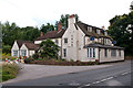
1
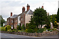
Judge's Cottages
18th/19th century house, now subdivided. Grade II listed - see www.historicengland.org.uk/listing/the-list/list-entry/1272643. The wall in front is separately grade II listed - see www.historicengland.org.uk/listing/the-list/list-entry/1243962.
Image: © Ian Capper
Taken: 22 Aug 2012
0.05 miles
3
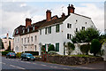
Bishop's Cottage
18th century house, now subdivided, once the home of Beilby Porteous, Bishop of London from 1787 to 1809. Grade II listed - see www.historicengland.org.uk/listing/the-list/list-entry/1243927.
Image: © Ian Capper
Taken: 22 Aug 2012
0.08 miles
4
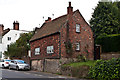
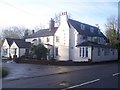
Cottage, Main Road
A brick and tile hung cottage on a stone base on Main Road in Sundridge.
Image: © Ian Capper
Taken: 22 Aug 2012
0.10 miles
5
Green Oak Barn, Warren Farm
Housing a furniture workshop. In the background is the spire of Sundridge Church.
Image: © Ian Capper
Taken: 22 Aug 2012
0.15 miles
6
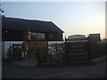
Trevor Lawrence Furniture, Main Road Sundridge
Image: © David Howard
Taken: 26 Mar 2012
0.15 miles
7
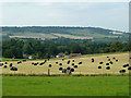
Baled hay for silage, Sundridge
Looking from the Greensand ridge across the Gault Clay vale to the chalk of the North Downs.
Image: © Robin Webster
Taken: 19 Aug 2011
0.15 miles
8
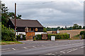
Sundridge House
This is a converted public house on the A25 Main Road. Now a Chinese Restaurant and Bar.
See http://www.sundridgehouse.com/ for more details.
Image: © David Anstiss
Taken: 17 Jan 2010
0.15 miles
9
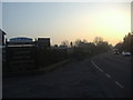
Sunset over Main Road Sundridge
Outside Trevor Lawrence Furniture
Image: © David Howard
Taken: 26 Mar 2012
0.15 miles
10
Sundridge House
Former 19th century pub (known as the Lamb Inn), converted to offices around 1999 and then to a Chinese restaurant in around 2003. Following a decline in business leading to closure, the owner has applied to convert the building to a house (planning permission for which was granted in 2010), but further plans to develop the adjacent car park for housing have been refused, due to the green belt/conservation area/AONB status of the site. At the time of this photo, another proposal is being considered, namely the redevelopment of part of the building for residential use, with a second detached house behind, and with the car park area being landscaped as a garden, to maintain the openness of the site.
Image: © Ian Capper
Taken: 22 Aug 2012
0.16 miles