IMAGES TAKEN NEAR TO
Ovenden Road, SEVENOAKS, TN14 6AN
Introduction
This page details the photographs taken nearby to Ovenden Road, TN14 6AN by members of the Geograph project.
The Geograph project started in 2005 with the aim of publishing, organising and preserving representative images for every square kilometre of Great Britain, Ireland and the Isle of Man.

There are currently over 7.5m images from over14,400 individuals and you can help contribute to the project by visiting https://www.geograph.org.uk
Image Map
Images are licensed for reuse under creativecommons.org/licenses/by-sa/2.0
Notes
- Clicking on the map will re-center to the selected point.
- The higher the marker number, the further away the image location is from the centre of the postcode.
Image Listing (19 Images Found)
Images are licensed for reuse under creativecommons.org/licenses/by-sa/2.0
Image
Details
Distance
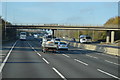
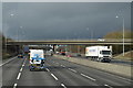
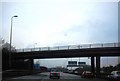
2
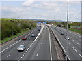
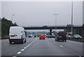
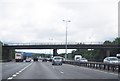
M25 Motorway
A photograph of the M25 near Sevenoaks taken early afternoon before the rush hour.
Image: © Jean Barrow
Taken: 1 May 2006
0.16 miles
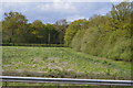
5
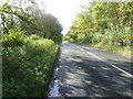
Ovenden Road near Claypit Shaw
Ovenden Road changes from a fairly quiet country lane at the bottom of Sundridge Hill to become a busy road as it approaches the Chevening cross roads. By now it has become the B2211. This is looking away from the crossroads. Claypit Shaw is on the left.
Image: © Marathon
Taken: 30 Oct 2012
0.18 miles