IMAGES TAKEN NEAR TO
Heathfield Road, SEVENOAKS, TN13 3DA
Introduction
This page details the photographs taken nearby to Heathfield Road, TN13 3DA by members of the Geograph project.
The Geograph project started in 2005 with the aim of publishing, organising and preserving representative images for every square kilometre of Great Britain, Ireland and the Isle of Man.

There are currently over 7.5m images from over14,400 individuals and you can help contribute to the project by visiting https://www.geograph.org.uk
Image Map (Loading...)


Getting Data...Please wait
Leaflet Map data © OpenStreetMap
Images are licensed for reuse under creativecommons.org/licenses/by-sa/2.0
Notes
- Clicking on the map will re-center to the selected point.
- The higher the marker number, the further away the image location is from the centre of the postcode.
Image Listing (71 Images Found)
Images are licensed for reuse under creativecommons.org/licenses/by-sa/2.0
Image
Details
Distance
1
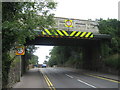
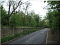
Railway bridge over Bradbourne Vale Road
This is bridge XB194 carrying the railway right to Sevenoaks Station from Dunton Green. The road heads to St Johns, Sevenoaks.
Image: © David Anstiss
Taken: 16 Aug 2009
0.06 miles
3
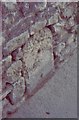
Old Milestone by the A25, Bradbourne Vale Road, Riverhead
Stone post (plate lost) by the A25, in parish of SEVENOAKS (SEVENOAKS District), Bradbourne Vale Road, just East of junction with Betenson Avenue, in base of stone wall by pavement, on South side of road. Wrotham iron plate, erected by the Wrotham Heath turnpike trust in the 19th century.
Inscription once read:-
(MAIDSTONE)
(17)
(GODSTONE)
(11½)
Kent HER.
HER Number: TQ 55 NW 342 https://www.heritagegateway.org.uk/Gateway/Results_Single.aspx?uid=MKE78086&resourceID=1005
Milestone Society National ID: KE_MDGS17A.
Image: © C Woodward
Taken: 10 Apr 2007
0.07 miles
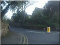
4
Bradbourne Vale Rd (A25) entering Riverhead
Image: © N Chadwick
Taken: 17 Feb 2010
0.07 miles
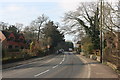
6
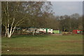
Sevenoaks Scout Camp, Bradbourne Vale Rd
Image: © N Chadwick
Taken: 17 Feb 2010
0.08 miles
7
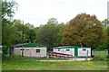
Scout Huts, Sevenoaks, Kent
3rd Sevenoaks, Riverhead and Dunton Green Scout Group.
Image: © Peter Trimming
Taken: 15 May 2010
0.09 miles
8
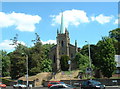
Riverhead Church
Right at the centre (A25/A224 roundabout is in view).
Image: © Chris Shaw
Taken: 18 Jun 2005
0.09 miles
9
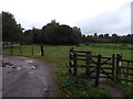
Darent Valley Path
The Darent Valley path runs northwards through the kissing gate to the right and through this horse field. The gate to the left leads to the local Scout hut, which can be seen on the left of the image.
Image: © ponponjo
Taken: 12 Oct 2019
0.10 miles
10
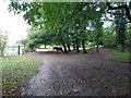
Darent Valley Path
The Darent Valley path continues southwards through this horse field. At the far end is a kissing gate leading onto Bradbourne Vale Road.
Image: © ponponjo
Taken: 12 Oct 2019
0.11 miles