IMAGES TAKEN NEAR TO
Den Lane, TONBRIDGE, TN12 9PX
Introduction
This page details the photographs taken nearby to Den Lane, TN12 9PX by members of the Geograph project.
The Geograph project started in 2005 with the aim of publishing, organising and preserving representative images for every square kilometre of Great Britain, Ireland and the Isle of Man.

There are currently over 7.5m images from over14,400 individuals and you can help contribute to the project by visiting https://www.geograph.org.uk
Image Map
Images are licensed for reuse under creativecommons.org/licenses/by-sa/2.0
Notes
- Clicking on the map will re-center to the selected point.
- The higher the marker number, the further away the image location is from the centre of the postcode.
Image Listing (12 Images Found)
Images are licensed for reuse under creativecommons.org/licenses/by-sa/2.0
Image
Details
Distance
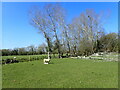
4
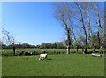
Lamb in a field on Easter Monday
This is just north of Den Cottages.
Image: © Marathon
Taken: 4 Apr 2021
0.19 miles
6
Lamb in a field on Easter Monday
This is just north of Den Cottages.
Image: © Marathon
Taken: 4 Apr 2021
0.20 miles
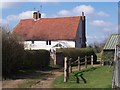
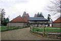
8
Crow Plain Oast, Collier Street, Kent
Image: © Oast House Archive
Taken: 15 Feb 2015
0.21 miles
9
Crow Plain Oast, Collier Street, Kent
Image: © Oast House Archive
Taken: 1 Oct 2008
0.21 miles
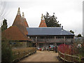
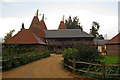
10
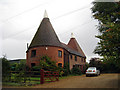
Crow Plain Oast
An unusual style of oasthouse conversion.
Image: © Robin Webster
Taken: 24 Feb 2007
0.22 miles