IMAGES TAKEN NEAR TO
Claygate, TONBRIDGE, TN12 9PJ
Introduction
This page details the photographs taken nearby to Claygate, TN12 9PJ by members of the Geograph project.
The Geograph project started in 2005 with the aim of publishing, organising and preserving representative images for every square kilometre of Great Britain, Ireland and the Isle of Man.

There are currently over 7.5m images from over14,400 individuals and you can help contribute to the project by visiting https://www.geograph.org.uk
Image Map (Loading...)


Getting Data...Please wait
Leaflet Map data © OpenStreetMap
Images are licensed for reuse under creativecommons.org/licenses/by-sa/2.0
Notes
- Clicking on the map will re-center to the selected point.
- The higher the marker number, the further away the image location is from the centre of the postcode.
Image Listing (31 Images Found)
Images are licensed for reuse under creativecommons.org/licenses/by-sa/2.0
Image
Details
Distance
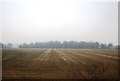
4
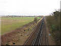
Railway near Collier Street
Looking from Spenny Lane bridge.
Image: © Oast House Archive
Taken: 15 Feb 2015
0.11 miles
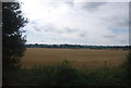
5
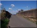
Green Lane road bridge
Road bridge leads over railway to Benover from Claygate. Railway heads right to Marden from Paddock Wood. Mast on other side of bridge and railway is a mobile phone mast.
Image: © David Anstiss
Taken: 1 Apr 2009
0.14 miles