IMAGES TAKEN NEAR TO
Goudhurst Road, TONBRIDGE, TN12 8EU
Introduction
This page details the photographs taken nearby to Goudhurst Road, TN12 8EU by members of the Geograph project.
The Geograph project started in 2005 with the aim of publishing, organising and preserving representative images for every square kilometre of Great Britain, Ireland and the Isle of Man.

There are currently over 7.5m images from over14,400 individuals and you can help contribute to the project by visiting https://www.geograph.org.uk
Image Map
Images are licensed for reuse under creativecommons.org/licenses/by-sa/2.0
Notes
- Clicking on the map will re-center to the selected point.
- The higher the marker number, the further away the image location is from the centre of the postcode.
Image Listing (18 Images Found)
Images are licensed for reuse under creativecommons.org/licenses/by-sa/2.0
Image
Details
Distance
1
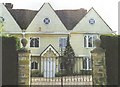
Broadford: an old "Clothmaster's Hall"
Broadford is another old "Clothmaster's Hall", part of which is 15th century. The timber framework has been covered in rough cast and the windows altered.
Broadcloth http://en.wikipedia.org/wiki/Broadcloth was made here for Queen Elizabeth I who visited it in 1573 when it was owned by the Austen family, ancestors of the writer Jane Austen. A descendant of hers still has one of the Queen's tokens which were issued to commemorate a royal visit. See also Image and Image
Other snippets from Horsmonden's history at: http://books.google.co.uk/books?id=2_ZstVBZSfIC&lpg=PA1&pg=PA99#v=onepage&q=&f=true . A Gallery is at: http://www.geograph.org.uk/gallery/the_history_of_horsmonden_8738
Image: © D Gore
Taken: Unknown
0.02 miles
3
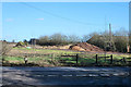
Wood waste
Piles of wood chips, brushwood and logs.
Image: © Robin Webster
Taken: 27 Feb 2015
0.08 miles
4
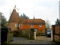
Broadford Oast, Goudhurst Road, Horsmonden, Kent
Image: © Oast House Archive
Taken: 4 Dec 2008
0.11 miles
5
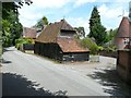
The Mill House & Millers Cottage, Brick Kiln Lane
The dormer windows of The Mill House can be seen behind the barn; Millers Cottage is beyond at right angles to the road. Both are grade II listed, dating from early 18th century and mid 19th century http://www.britishlistedbuildings.co.uk/en-169840-mill-house-millers-cottage-horsmonden-ke
Image: © John Baker
Taken: 30 Jun 2013
0.11 miles
6
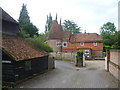
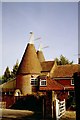
Mill Oast
Mill Oast is seen here from Brick Kiln Lane. For more information on Mill Oast see http://www.geograph.org.uk/photo/1823320
Image: © Marathon
Taken: 14 Jun 2014
0.11 miles
7
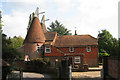
Mill Oast, Brick Kiln Lane, Horsmonden, Kent
Image: © Oast House Archive
Taken: 25 Sep 2008
0.12 miles
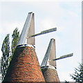
9
Mill Oast, Brick Kiln Lane, Horsmonden, Kent
Image: © Oast House Archive
Taken: 27 Jan 2007
0.13 miles
10
Mill Oast, Brick Kiln Lane, Horsmonden, Kent
Image: © Oast House Archive
Taken: 1 Mar 2003
0.14 miles