IMAGES TAKEN NEAR TO
Coventry Road, TONBRIDGE, TN10 4QE
Introduction
This page details the photographs taken nearby to Coventry Road, TN10 4QE by members of the Geograph project.
The Geograph project started in 2005 with the aim of publishing, organising and preserving representative images for every square kilometre of Great Britain, Ireland and the Isle of Man.

There are currently over 7.5m images from over14,400 individuals and you can help contribute to the project by visiting https://www.geograph.org.uk
Image Map
Images are licensed for reuse under creativecommons.org/licenses/by-sa/2.0
Notes
- Clicking on the map will re-center to the selected point.
- The higher the marker number, the further away the image location is from the centre of the postcode.
Image Listing (67 Images Found)
Images are licensed for reuse under creativecommons.org/licenses/by-sa/2.0
Image
Details
Distance
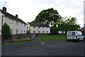
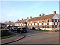
8
Royal West Kent Avenue
C.1950s housing on Royal West Kent Avenue.
Image: © Ian Capper
Taken: 30 Jun 2021
0.09 miles
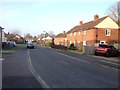
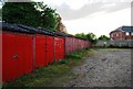
9
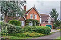
68 The Ridgeway
Old planning documents name this building as Cage Farm Lodge, and old maps show that it stood at the entrance to Cage Farm, now all redeveloped.
Image: © Ian Capper
Taken: 30 Jun 2021
0.10 miles
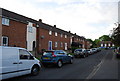
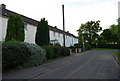
10
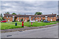
Canterbury Crescent
c.1950s terrace on Canterbury Crescent in the Cage Green area of Tonbridge, one of a number of roads in the area named after cathedrals, another being Norwich Avenue in the foreground.
Image: © Ian Capper
Taken: 30 Jun 2021
0.11 miles