IMAGES TAKEN NEAR TO
The Steadings, Moss Lane, MARKET DRAYTON, TF9 4RS
Introduction
This page details the photographs taken nearby to The Steadings, Moss Lane, TF9 4RS by members of the Geograph project.
The Geograph project started in 2005 with the aim of publishing, organising and preserving representative images for every square kilometre of Great Britain, Ireland and the Isle of Man.

There are currently over 7.5m images from over14,400 individuals and you can help contribute to the project by visiting https://www.geograph.org.uk
Image Map (Loading...)


Getting Data...Please wait
Leaflet Map data © OpenStreetMap
Images are licensed for reuse under creativecommons.org/licenses/by-sa/2.0
Notes
- Clicking on the map will re-center to the selected point.
- The higher the marker number, the further away the image location is from the centre of the postcode.
Image Listing (10 Images Found)
Images are licensed for reuse under creativecommons.org/licenses/by-sa/2.0
Image
Details
Distance
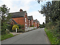
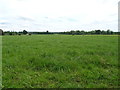
3
Betton village
The small village of Betton. The barns on the left have been converted to residential use.
Image: © Simon Huguet
Taken: 21 Feb 2009
0.07 miles
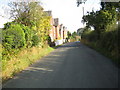
4
The lane at Betton
Looking south towards Betton Farm
Image: © Peter Fleming
Taken: 11 Oct 2007
0.07 miles
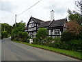
5
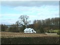
Betton church
A genuine 'tin tabernacle', loving restored and converted into a smart and unusual dwelling house
Image: © Simon Huguet
Taken: 21 Feb 2009
0.09 miles
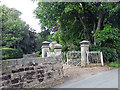
6
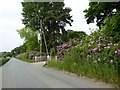
Hedge with rhododendrons outside Betton Hall
Image: © Jonathan Hutchins
Taken: 4 Jun 2016
0.13 miles
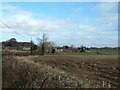
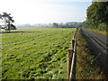
8
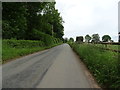
Minor road towards Norton in Hales
Heading north east from Betton.
Image: © JThomas
Taken: 1 Jun 2019
0.17 miles
9
Houses in Betton
Rural housing alongside the lane in Betton
Image: © Peter Fleming
Taken: 11 Oct 2007
0.21 miles