IMAGES TAKEN NEAR TO
Ashley Heath, MARKET DRAYTON, TF9 4PL
Introduction
This page details the photographs taken nearby to TF9 4PL by members of the Geograph project.
The Geograph project started in 2005 with the aim of publishing, organising and preserving representative images for every square kilometre of Great Britain, Ireland and the Isle of Man.

There are currently over 7.5m images from over14,400 individuals and you can help contribute to the project by visiting https://www.geograph.org.uk
Image Map (Loading...)


Getting Data...Please wait
Leaflet Map data © OpenStreetMap
Images are licensed for reuse under creativecommons.org/licenses/by-sa/2.0
Notes
- Clicking on the map will re-center to the selected point.
- The higher the marker number, the further away the image location is from the centre of the postcode.
Image Listing (10 Images Found)
Images are licensed for reuse under creativecommons.org/licenses/by-sa/2.0
Image
Details
Distance
2
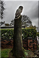
Wood Carved Owl, Ashley Heath
Wood Carving at the side of the road.
Image: © Brian Deegan
Taken: 8 May 2021
0.19 miles
4
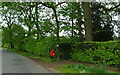
Elizabeth II postbox on Mucklestone Wood Lane, Loggerheads
Postbox No. TF9 463.
See Image] for close up.
Image: © JThomas
Taken: 1 Jun 2019
0.21 miles
5
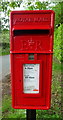
Close up, Elizabeth II postbox on Mucklestone Wood Lane, Loggerheads
Postbox No. TF9 463.
See Image] for wider view.
Image: © JThomas
Taken: 1 Jun 2019
0.21 miles
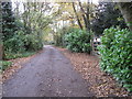
6
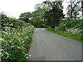
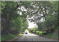
Mucklestone Wood Lane, Loggerheads
Looking south east.
Image: © JThomas
Taken: 1 Jun 2019
0.22 miles
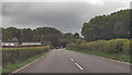
7
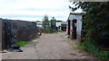
Westfields Farm
Looking east from Pinewood Road.
Image: © Jonathan Billinger
Taken: 6 Sep 2016
0.23 miles
8
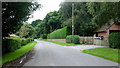
Pinewood Road
Looking south by Westfields Farm.
Image: © Jonathan Billinger
Taken: 6 Sep 2016
0.23 miles
9
Ashley Heath
Park at end of Tower Road on grey dry morning. Top on road beside house called Whinberry whose owner wondered what I was doing with my camera and GPS.
Name: Ashley Heath
Hill number: 5391
Height: 236m / 774ft
Area: 36: Lancashire, Cheshire & the Southern Pennines
Class: Hu
Grid ref: SJ745357 (est)
Drop: 119m
Col: 117m SJ792406
Image: © Rude Health
Taken: 31 Oct 2010
0.25 miles
10
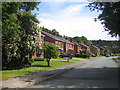
Loggerheads: Chestnut Road
Detached houses in the more recent housing estate in Chestnut Road.
Image: © Nigel Cox
Taken: 15 Jun 2007
0.25 miles