IMAGES TAKEN NEAR TO
Adderley, MARKET DRAYTON, TF9 3TD
Introduction
This page details the photographs taken nearby to TF9 3TD by members of the Geograph project.
The Geograph project started in 2005 with the aim of publishing, organising and preserving representative images for every square kilometre of Great Britain, Ireland and the Isle of Man.

There are currently over 7.5m images from over14,400 individuals and you can help contribute to the project by visiting https://www.geograph.org.uk
Image Map
Images are licensed for reuse under creativecommons.org/licenses/by-sa/2.0
Notes
- Clicking on the map will re-center to the selected point.
- The higher the marker number, the further away the image location is from the centre of the postcode.
Image Listing (12 Images Found)
Images are licensed for reuse under creativecommons.org/licenses/by-sa/2.0
Image
Details
Distance
1
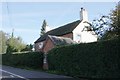
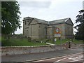
Old Toll House, Adderley
Toll Cottage by the A529, in the parish of Adderley.
To be surveyed
Milestone Society National ID: SA.ADD
Image: © Milestone Society
Taken: Unknown
0.04 miles
4

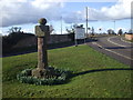
Sundial, Adderley
Plain sun-dial with steps, circular shaft, square head with 2 surviving gnomons and ball finial. Dated 1774 according to local records. Those parishioners who could tell the time would no doubt have found it useful to discover whether they were early, late or on time for communion.
Image: © Mike Faherty
Taken: 26 Aug 2008
0.13 miles
5

Mounting stone at Adderley
To help the gentry with horses to mount/dismount after/before Sunday communion. English Heritage thinks it's C18; has obviously had some use (see wear on the treads).
Image: © Mike Faherty
Taken: 26 Aug 2008
0.13 miles
7

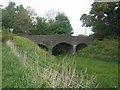
Old Direction Sign - Signpost by Rectory Lane, Adderley
Annulus finial - 4 arms; Shropshire CC halo by the UC road, in parish of Adderley (North Shropshire District), junction of Rectory Lane with Green Bank, on verge, against wire fence, beside end of railway bridge.
Surveyed
Milestone Society National ID: SA_SJ6639
Image: © Milestone Society
Taken: Unknown
0.14 miles

9
St Peter's Church, Adderley
Renovation in progress
Image: © John Lord
Taken: 22 Mar 2010
0.15 miles
10
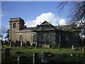
St Peter's Church
The sandstone church dates largely from 1800 with some earlier elements. It is associated with the local landowners the Kilmorey family of Shavington Park. The church although still in use for worship is partly supported by the Churches Conservation Trust.
Image: © John M
Taken: 10 May 2009
0.16 miles