IMAGES TAKEN NEAR TO
Hopton, Hodnet, MARKET DRAYTON, TF9 3LF
Introduction
This page details the photographs taken nearby to TF9 3LF by members of the Geograph project.
The Geograph project started in 2005 with the aim of publishing, organising and preserving representative images for every square kilometre of Great Britain, Ireland and the Isle of Man.

There are currently over 7.5m images from over14,400 individuals and you can help contribute to the project by visiting https://www.geograph.org.uk
Image Map
Images are licensed for reuse under creativecommons.org/licenses/by-sa/2.0
Notes
- Clicking on the map will re-center to the selected point.
- The higher the marker number, the further away the image location is from the centre of the postcode.
Image Listing (7 Images Found)
Images are licensed for reuse under creativecommons.org/licenses/by-sa/2.0
Image
Details
Distance
2
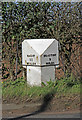
Old Milepost by the A53, north of Hopton Methodist Chapel
Cast iron post by the A53, north of Hopton Methodist Chapel, on west side of road. In parish of HODNET (NORTH SHROPSHIRE District), Salop iron T-post, erected by the County Council in the 19th/20th century. Removed from the east side of road, recovered by the council, and then re-installed on the west side of the road, so the directions are the wrong way round.
Inscription reads:- : SALOP / 11 / MILES : : DRAYTON / 8 / MILES :
Milestone Society National ID: SA_MDSB08.
Image: © John Haynes
Taken: 16 Mar 2020
0.11 miles
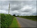
7
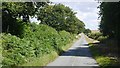
Road to High Hatton
A long straight passing a groundwater pumping station.
Image: © Richard Webb
Taken: 25 Jul 2015
0.19 miles