IMAGES TAKEN NEAR TO
Blandford Way, MARKET DRAYTON, TF9 3FS
Introduction
This page details the photographs taken nearby to Blandford Way, TF9 3FS by members of the Geograph project.
The Geograph project started in 2005 with the aim of publishing, organising and preserving representative images for every square kilometre of Great Britain, Ireland and the Isle of Man.

There are currently over 7.5m images from over14,400 individuals and you can help contribute to the project by visiting https://www.geograph.org.uk
Image Map (Loading...)


Getting Data...Please wait
Leaflet Map data © OpenStreetMap
Images are licensed for reuse under creativecommons.org/licenses/by-sa/2.0
Notes
- Clicking on the map will re-center to the selected point.
- The higher the marker number, the further away the image location is from the centre of the postcode.
Image Listing (3 Images Found)
Images are licensed for reuse under creativecommons.org/licenses/by-sa/2.0
Image
Details
Distance
1
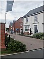
Blandford Way
Infil housing, Market Drayton. More to this square than windscreens on the A53.
There is one of the modern World War I silhouette memorials here.
Image: © Richard Webb
Taken: 11 Jun 2021
0.06 miles
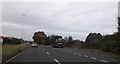
3

Approaching Longslow Road junction on A53
Image: © John Firth
Taken: 15 Jun 2013
0.23 miles