IMAGES TAKEN NEAR TO
Newport Road, MARKET DRAYTON, TF9 2TL
Introduction
This page details the photographs taken nearby to Newport Road, TF9 2TL by members of the Geograph project.
The Geograph project started in 2005 with the aim of publishing, organising and preserving representative images for every square kilometre of Great Britain, Ireland and the Isle of Man.

There are currently over 7.5m images from over14,400 individuals and you can help contribute to the project by visiting https://www.geograph.org.uk
Image Map
Images are licensed for reuse under creativecommons.org/licenses/by-sa/2.0
Notes
- Clicking on the map will re-center to the selected point.
- The higher the marker number, the further away the image location is from the centre of the postcode.
Image Listing (13 Images Found)
Images are licensed for reuse under creativecommons.org/licenses/by-sa/2.0
Image
Details
Distance
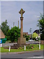
2

A41 - Pixley Lane overbridge, Hinstock
Image: © Peter Whatley
Taken: 17 Jan 2012
0.08 miles
3
St Oswald's Church, Hinstock
View of the eastern end of the church. Most of the church was built in the early 18th century, with the south aisle in 1850. It is built of red sandstone.
Image: © Eirian Evans
Taken: 26 Mar 2010
0.11 miles
4
To Newport 6 Miles
Old milestone on what would have been the A41 before being by passed at Hinstock, Shropshire. For close up view see http://www.geograph.org.uk/photo/5575317
Image: © Keith Evans
Taken: 16 Sep 2017
0.15 miles
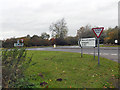
5

A41/A529 junction, Hinstock
The original course of the A41 goes through the village while today's route bypasses it.
Image: © Peter Whatley
Taken: 17 Jan 2012
0.15 miles

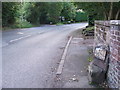
7

Old Milestone by the A529, near Holly House, Hinstock parish
Metal plates attached to earlier carved stone post, by the A529, in parish of HINSTOCK (NORTH SHROPSHIRE District), 10m South of Holly House, against wall, on West side of road. Chester Road post, erected by the Newport & Ternhill turnpike trust in the 19th century.
Inscription reads:-
: TO / CHESTER / 34 / MILES : : HINSTOCK : : TO / NEWPORT / 6 MILES :
Grade II listed.
List Entry Number: 1176123 https://historicengland.org.uk/listing/the-list/list-entry/1176123
Milestone Society National ID: SA_CHNP34.
Image: © A Reade/J Higgins
Taken: 1 Sep 2007
0.16 miles
8

Old Milestone
Old milestone on what would have been the A41 before being by passed at Hinstock, Shropshire. For overall view see http://www.geograph.org.uk/photo/5575320
Image: © Keith Evans
Taken: 16 Sep 2017
0.16 miles
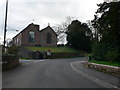
10

Old Toll House, Hinstock
Toll House by the A529, in the parish of Hinstock, Tollgate House (or Holly House), Newport Road, TF9 2TH.
To be surveyed
Milestone Society National ID: SA.HIN02
Image: © Milestone Society
Taken: Unknown
0.17 miles