IMAGES TAKEN NEAR TO
Ashlea Court, MARKET DRAYTON, TF9 1HZ
Introduction
This page details the photographs taken nearby to Ashlea Court, TF9 1HZ by members of the Geograph project.
The Geograph project started in 2005 with the aim of publishing, organising and preserving representative images for every square kilometre of Great Britain, Ireland and the Isle of Man.

There are currently over 7.5m images from over14,400 individuals and you can help contribute to the project by visiting https://www.geograph.org.uk
Image Map
Images are licensed for reuse under creativecommons.org/licenses/by-sa/2.0
Notes
- Clicking on the map will re-center to the selected point.
- The higher the marker number, the further away the image location is from the centre of the postcode.
Image Listing (181 Images Found)
Images are licensed for reuse under creativecommons.org/licenses/by-sa/2.0
Image
Details
Distance
1
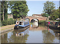
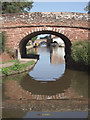
Shropshire Union Canal at Market Drayton, Shropshire
Approaching Newcastle Road Bridge, No 62. Note the WW2 pillbox on the left.
Image]
Image: © Roger D Kidd
Taken: 25 Aug 2011
0.03 miles
2
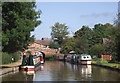
Shropshire Union Canal at Market Drayton, Shropshire
Approaching Newcastle Road Bridge, No 62.
Image: © Roger D Kidd
Taken: 25 Aug 2011
0.03 miles
3
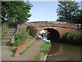
Newcastle Road Bridge in Market Drayton, Shropshire
Bridge No 62 on the Shropshire Union Canal. The patch between the towpath and the steps to the road appear to have been "gardened" but was looking uncared for today. Some attractive orange poppies were in bloom.
Image]
Image: © Roger D Kidd
Taken: 25 Aug 2011
0.03 miles
4
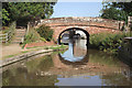
Newcastle Road Bridge in Market Drayton, Shropshire
Bridge No 62 on the Shropshire Union Canal built of local Triassic red sandstone. The patch between the towpath and the steps to the road appear to have been "gardened" but was looking uncared for today. Some attractive orange poppies were in bloom.
Image]
Image: © Roger D Kidd
Taken: 25 Aug 2011
0.03 miles
5
Newcastle Road Bridge in Market Drayton, Shropshire
Bridge No 62 on the Shropshire Union Canal, built of local Triassic red sandstone.
Image: © Roger D Kidd
Taken: 25 Aug 2011
0.03 miles
6
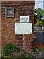
It might have been legal in the 1950s...
But surely you can't do that to kids these days. Can you?
This faded signage is on the wall of The Talbot pub.
Image: © Richard Law
Taken: 29 Jun 2014
0.03 miles
7
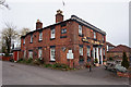
The Talbot on Newcastle Road, Market Drayton
http://www.geograph.org.uk/photo/4904346
Image: © Ian S
Taken: 1 Apr 2016
0.03 miles
8
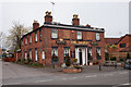
The Talbot on Newcastle Road, Market Drayton
http://www.geograph.org.uk/photo/4904346
Image: © Ian S
Taken: 1 Apr 2016
0.03 miles
9
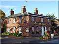
The Talbot Inn, Market Drayton, Shropshire
This public house by Newcastle Road near the canal, and dating from about 1840, is shown here in 2012. It has since closed and been converted into residential accommodation.
Image: © Roger Kidd
Taken: 17 Oct 2012
0.03 miles
10
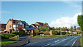
Housing by Newcastle Road in Market Drayton, Shropshire
This shows Newcastle Road at the junction with Sambrook Crescent.
Image: © Roger Kidd
Taken: 17 Oct 2012
0.03 miles