IMAGES TAKEN NEAR TO
St. Lukes Road, TELFORD, TF8 7PX
Introduction
This page details the photographs taken nearby to St. Lukes Road, TF8 7PX by members of the Geograph project.
The Geograph project started in 2005 with the aim of publishing, organising and preserving representative images for every square kilometre of Great Britain, Ireland and the Isle of Man.

There are currently over 7.5m images from over14,400 individuals and you can help contribute to the project by visiting https://www.geograph.org.uk
Image Map
Images are licensed for reuse under creativecommons.org/licenses/by-sa/2.0
Notes
- Clicking on the map will re-center to the selected point.
- The higher the marker number, the further away the image location is from the centre of the postcode.
Image Listing (741 Images Found)
Images are licensed for reuse under creativecommons.org/licenses/by-sa/2.0
Image
Details
Distance
1
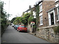
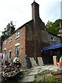
The Old Armoury - St Luke's Road (South View)
Used as the armoury for D Company, 4th Battalion, King's Own Shropshire Light Infantry in 1914. The former 19C workshops were recently converted into residential units with an attached house, South View at this end.
Image: © John M
Taken: 29 Apr 2014
0.01 miles
2
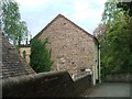
The Old Armoury - St Luke's Road
Used as the armoury for D Company, 4th Battalion, King's Own Shropshire Light Infantry in 1914. The former 19C workshops were recently converted into residential units with an attached house, South View at far end.
Image: © John M
Taken: 29 Apr 2014
0.01 miles
3
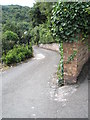
Looking down New Road
Taken from just past the parish church.
Image: © Basher Eyre
Taken: 12 Aug 2009
0.01 miles
4
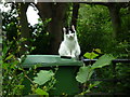
Cat at St. Luke's Road (Ironbridge)
The first of four cats we met on our visit to Ironbridge, this one stared directly into our souls when we said hello to it, and stayed there for the whole time when we spoke to it.
Image: © Fabian Musto
Taken: 30 May 2019
0.01 miles
5
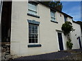
13 Church Hill, Ironbridge
No 13 was built around the early part of the 19th century, and was Grade II listed https://britishlistedbuildings.co.uk/101374902-13-church-hill-the-gorge in 1983. The modern porch mentioned in the listing has been removed as part of renovation works, currently underway in Sept 2018.
Image: © Richard Law
Taken: 2 Sep 2018
0.01 miles
6

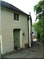
24 St Luke's Road, Ironbridge
A partial glimpse of 24 St Luke's Road, which dates from the early-to-mid 19th century, and which was Grade II listed https://britishlistedbuildings.co.uk/101038662-24-st-lukes-road-the-gorge#.XqWG3mhKjcs & https://historicengland.org.uk/listing/the-list/list-entry/1038662 in 1983.
Image: © Richard Law
Taken: 24 Apr 2020
0.01 miles
7
16 Church Hill, Ironbridge
Built in the early 19th century, and Grade II listed https://britishlistedbuildings.co.uk/101038636-16-church-hill-the-gorge#.W8Oe-NQrLGg in 1974, at which time the description suggests it wasn't painted (russet brick is mentioned)
Image: © Richard Law
Taken: 2 Sep 2018
0.02 miles
8
The Old Armoury - St Luke's Road (South View)
Used as the armoury for D Company, 4th Battalion, King's Own Shropshire Light Infantry in 1914. The former 19C workshops were recently converted into residential units with an attached house, South View at this end.
Image: © John M
Taken: 29 Apr 2014
0.02 miles
9
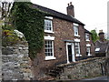
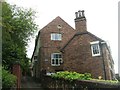
12, Church Hill, Ironbridge
Also now known as Ivy Cottage, this two-storey, red-brick house dates from the early 19th century, and was given a grade II listing http://www.britishlistedbuildings.co.uk/101207428-12-church-hill-the-gorge#.WRoLxtQrLGg in 1974.
Image: © Richard Law
Taken: 17 Apr 2017
0.02 miles