IMAGES TAKEN NEAR TO
Lincoln Hill, TELFORD, TF8 7NX
Introduction
This page details the photographs taken nearby to Lincoln Hill, TF8 7NX by members of the Geograph project.
The Geograph project started in 2005 with the aim of publishing, organising and preserving representative images for every square kilometre of Great Britain, Ireland and the Isle of Man.

There are currently over 7.5m images from over14,400 individuals and you can help contribute to the project by visiting https://www.geograph.org.uk
Image Map
Images are licensed for reuse under creativecommons.org/licenses/by-sa/2.0
Notes
- Clicking on the map will re-center to the selected point.
- The higher the marker number, the further away the image location is from the centre of the postcode.
Image Listing (89 Images Found)
Images are licensed for reuse under creativecommons.org/licenses/by-sa/2.0
Image
Details
Distance
4

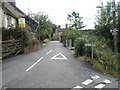
South Telford Way towards Church Road, Ironbridge
The South Telford Way is a circular walking route within the Parishes of Stirchley & Brookside, Madeley, Dawley Hamlets and the Gorge. It is approximately 18km/12 miles in length. The route follows the remains of a network of canals, tramways, railways, coal mines, brickworks, potteries and ironworks that once flourished in the area. The path is marked by green and white waymark discs.
Image: © Mat Fascione
Taken: 1 Sep 2023
0.06 miles
5

Cottages along Church Road at Ironbridge
Image: © Mat Fascione
Taken: 1 Sep 2023
0.07 miles
6
South Telford Way at Lincoln Hill
The South Telford Way is a circular walking route within the Parishes of Stirchley & Brookside, Madeley, Dawley Hamlets and the Gorge. It is approximately 18km/12 miles in length. The route follows the remains of a network of canals, tramways, railways, coal mines, brickworks, potteries and ironworks that once flourished in the area. The path is marked by green and white waymark discs.
Image: © Mat Fascione
Taken: 1 Sep 2023
0.07 miles
7
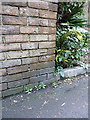
OS benchmark - Ironbridge, top of Lincoln Hill
An OS cutmark in a brick wall near the top of the cruelly steep Lincoln Hill; originally levelled at 110.907m above Ordnance Datum Newlyn.
Image: © Richard Law
Taken: 1 Mar 2014
0.11 miles
8
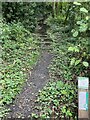
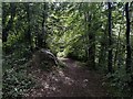
Footpath up to Lincoln Hill, Ironbridge Gorge
A steep set of well laid steps lead up Lincoln Hill to the Rotunda viewpoint. Well worth the effort in lovely deciduous woodland.
Image: © Andrew Shannon
Taken: 3 Sep 2024
0.11 miles
9

The South Telford Way at Coalbrookdale
The South Telford Way is a circular walking route within the Parishes of Stirchley & Brookside, Madeley, Dawley Hamlets and the Gorge. It is approximately 18km/12 miles in length. The route follows the remains of a network of canals, tramways, railways, coal mines, brickworks, potteries and ironworks that once flourished in the area. The path is marked by green and white waymark discs.
Image: © Mat Fascione
Taken: 1 Sep 2023
0.12 miles
10
Looking from Lincoln Hill into Hodge Bowers
Image: © Basher Eyre
Taken: 12 Aug 2009
0.13 miles