IMAGES TAKEN NEAR TO
Mollett Drive, TELFORD, TF8 7BH
Introduction
This page details the photographs taken nearby to Mollett Drive, TF8 7BH by members of the Geograph project.
The Geograph project started in 2005 with the aim of publishing, organising and preserving representative images for every square kilometre of Great Britain, Ireland and the Isle of Man.

There are currently over 7.5m images from over14,400 individuals and you can help contribute to the project by visiting https://www.geograph.org.uk
Image Map
Images are licensed for reuse under creativecommons.org/licenses/by-sa/2.0
Notes
- Clicking on the map will re-center to the selected point.
- The higher the marker number, the further away the image location is from the centre of the postcode.
Image Listing (12 Images Found)
Images are licensed for reuse under creativecommons.org/licenses/by-sa/2.0
Image
Details
Distance
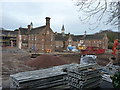
1
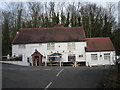
Conversion work underway at Lincoln Grange
Lincoln Grange was most recently a nursing home, but prior to that had been the Beeches Hospital since the 1930s, and was built originally in the mid 1870s as the Madeley Union Workhouse. It's currently being converted to residential use. The site is quite extensive, and is subject to a Grade II listing https://britishlistedbuildings.co.uk/101391962-lincoln-grange-formerly-madeley-union-workhouse-the-gorge#.XI65hCj7TIU which was granted in 2007. It was built to replace the nearby Image, which was seriously overcrowded, and by 1881 housed a total of 112 male & female residents, aged between 20 and early 80s, mostly described as 'paupers', along with a few of their young offspring. Many were locals, hailing from Madeley, Ironbridge, Bridgnorth, Broseley, Much Wenlock, Wellington, Shifnal, Shrewsbury etc, but a few came from further afield, and included one chap from Llanelli, a Jarrow man, a Yorkshireman from Harrogate and even one George Harley from Kinsale in County Cork, Ireland.
Image: © Richard Law
Taken: 3 Feb 2019
0.10 miles
2

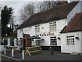
Lincoln Grange - conversion work now completed
Slightly more than a year after Image was taken, pretty much all the conversion of the former Lincoln Grange (formerly the Madeley Valley Union Workhouse) has now been completed, and most of the houses are occupied. Seen here is the eastern wing of former wards, which lie behind the red skips in the photo above; and shows the standard to which the conversion has been done. A full description of the buildings and their history is at https://britishlistedbuildings.co.uk/101391962-lincoln-grange-formerly-madeley-union-workhouse-the-gorge#.XqgpXWhKjcs & https://historicengland.org.uk/listing/the-list/list-entry/1391962 & http://www.workhouses.org.uk/Madeley/
Image: © Richard Law
Taken: 24 Apr 2020
0.10 miles
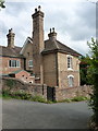
3
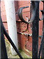
OS benchmark - Ironbridge, 49 Beech Road
A rather inaccessible benchmark on the gable wall of the house; originally levelled at 131.549m above Ordnance Datum Newlyn.
Image: © Richard Law
Taken: 27 Mar 2016
0.11 miles
4
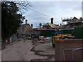
Lincoln Grange - rear of the buildings
Conversion to residential work at the former Lincoln Grange nursing home is well underway, turning the one-time Beeches Hospital and Madeley Union workhouse into a series of apartments and homes. The whole building was give a Grade II listing https://britishlistedbuildings.co.uk/101391962-lincoln-grange-formerly-madeley-union-workhouse-the-gorge#.XJM-_Cj7RPY in 2007, and is thought to be the country's first 'pavilion-plan' workhouse, built in the early 1870s. The 1881 census records a Master & Matron, plus one nurse, who looked after 112 residents aged between 20 and their early 80s.
Image: © Richard Law
Taken: 3 Feb 2019
0.12 miles
5
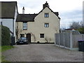
The Lodge cottage
One half (the western part) of a 16th or 17th century hunting lodge built for Madeley Court house, and Grade II listed https://britishlistedbuildings.co.uk/101207696-the-lodge-the-gorge#.XJOHxSj7RPY in 1983. The other part is Image
Image: © Richard Law
Taken: 3 Feb 2019
0.20 miles
6
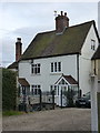
The Lodge house
The western section of a 16th or 17th century hunting lodge built for Madeley Court house, and Grade II listed https://britishlistedbuildings.co.uk/101207696-the-lodge-the-gorge#.XJOHxSj7RPY in 1983. The other part is Image
Image: © Richard Law
Taken: 3 Feb 2019
0.20 miles
7

The South Telford Way at Coalbrookdale
The South Telford Way is a circular walking route within the Parishes of Stirchley & Brookside, Madeley, Dawley Hamlets and the Gorge. It is approximately 18km/12 miles in length. The route follows the remains of a network of canals, tramways, railways, coal mines, brickworks, potteries and ironworks that once flourished in the area. The path is marked by green and white waymark discs.
Image: © Mat Fascione
Taken: 1 Sep 2023
0.22 miles
8
Woodland Grange, Ironbridge
A rear view of Woodland Grange, a large buff-brick house built around 1960. It attracted a Grade II listing https://britishlistedbuildings.co.uk/101038678-woodland-grange-the-gorge#.X20QEWhKjIU & https://historicengland.org.uk/listing/the-list/list-entry/1038678 in 1974.
Image: © Richard Law
Taken: 6 Aug 2020
0.23 miles