IMAGES TAKEN NEAR TO
Brick Kiln Bank, TELFORD, TF7 5LH
Introduction
This page details the photographs taken nearby to Brick Kiln Bank, TF7 5LH by members of the Geograph project.
The Geograph project started in 2005 with the aim of publishing, organising and preserving representative images for every square kilometre of Great Britain, Ireland and the Isle of Man.

There are currently over 7.5m images from over14,400 individuals and you can help contribute to the project by visiting https://www.geograph.org.uk
Image Map
Images are licensed for reuse under creativecommons.org/licenses/by-sa/2.0
Notes
- Clicking on the map will re-center to the selected point.
- The higher the marker number, the further away the image location is from the centre of the postcode.
Image Listing (18 Images Found)
Images are licensed for reuse under creativecommons.org/licenses/by-sa/2.0
Image
Details
Distance
1
Pedestrian Level Crossing near Woodside
This is the goods line between Madeley Junction & the Power Station at Ironbridge.
Image: © Row17
Taken: 1 Mar 2008
0.03 miles
3
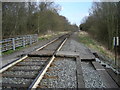
Lightmoor Junction
The left fork here has been taken up. Further north, along its line, is the Horsehay Steam Trust. The right fork leads to Madeley Junction, a real junction this time, on the Wolverhampton to Shrewsbury line. Only goods trains; long lines of coal trucks heading to & from the Ironbridge Gorge Power Station; pass along this line now.
Image: © Mike White
Taken: 17 May 2009
0.05 miles
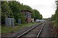
4
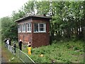
View from a Telford-Ironbridge train - Lightmoor Junction Signal box
Image: © Nigel Thompson
Taken: 9 Jun 2019
0.05 miles
5

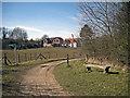
South Telford Way towards Coalbrookdale
The South Telford Way is a circular walking route within the Parishes of Stirchley & Brookside, Madeley, Dawley Hamlets and the Gorge. It is approximately 18km/12 miles in length. The route follows the remains of a network of canals, tramways, railways, coal mines, brickworks, potteries and ironworks that once flourished in the area. The path is marked by green and white waymark discs.
Image: © Mat Fascione
Taken: 1 Sep 2023
0.07 miles
6
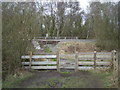
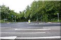
Footpath to Lightmoor
The footpath here crosses the A4169.
Image: © Mike White
Taken: 17 May 2009
0.10 miles
7
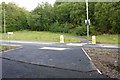
Brick Kiln Bank
This junction on the A4169 Crackshall Lane has been much improved. It now leads to the new Lightmoor View Care Home.
Image: © Mike White
Taken: 17 May 2009
0.11 miles
10
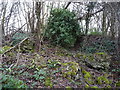
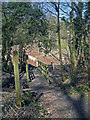
Remains of Lightmoor Furnaces
Extremely ruinous now, but these vegetation-covered structures and walls are the remains of a mid 18th century (1750s) blast furnace, which was Grade II listed https://britishlistedbuildings.co.uk/101025235-lightmoor-furnaces-dawley-hamlets#.Xn98YYj7TIU & https://historicengland.org.uk/listing/the-list/list-entry/1025235 in 1974.
Image: © Richard Law
Taken: 2 Feb 2020
0.17 miles