IMAGES TAKEN NEAR TO
Church Street, TELFORD, TF7 5BN
Introduction
This page details the photographs taken nearby to Church Street, TF7 5BN by members of the Geograph project.
The Geograph project started in 2005 with the aim of publishing, organising and preserving representative images for every square kilometre of Great Britain, Ireland and the Isle of Man.

There are currently over 7.5m images from over14,400 individuals and you can help contribute to the project by visiting https://www.geograph.org.uk
Image Map
Images are licensed for reuse under creativecommons.org/licenses/by-sa/2.0
Notes
- Clicking on the map will re-center to the selected point.
- The higher the marker number, the further away the image location is from the centre of the postcode.
Image Listing (93 Images Found)
Images are licensed for reuse under creativecommons.org/licenses/by-sa/2.0
Image
Details
Distance
1

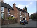
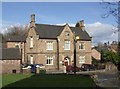
The old National School, Madeley
Now converted to a private house, the former National School is dated 1814 in the gable plaque, and was Grade II listed https://www.britishlistedbuildings.co.uk/101033275-former-national-school-madeley#.WuF8ZPnwaM8 in 1983.
Image: © Richard Law
Taken: 7 Apr 2018
0.01 miles
2
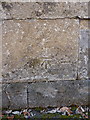
OS benchmark - Madeley, churchyard wall
An OS cutmark on the stone wall bounding the churchyard; originally levelled at 117.888m above Ordnance Datum Newlyn.
Image: © Richard Law
Taken: 19 Sep 2015
0.01 miles
3
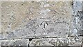
St Michael's Madeley Benchmark
The Cut Ordnance Survey Benchmark adjacent to St Michael's Church in Madeley. It is cut into the roadside wall on Church Street. Last levelled by the OS in 1979. What3Words: obvious.apes.jugs
Image: © Anthony Rowley
Taken: 15 Jul 2021
0.01 miles
4
Six Bells
Small local facing the village green near to St Michaels Church.
Image: © John M
Taken: 9 Mar 2008
0.01 miles
5
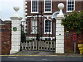
Gatepiers of the Old Vicarage, Madeley
Grade II* listed https://www.britishlistedbuildings.co.uk/101208716-gatepiers-west-of-the-old-vicarage-madeley#.WuF44PnwaM8 in 1983, the gatepillars were erected around 1700, and complement the similarly-dated vicarage Image in the background.
Image: © Richard Law
Taken: 7 Apr 2018
0.01 miles
6
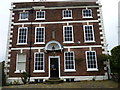
The Old Vicarage, Madeley
The vicarage was built around 1700, which suggests it originally served an earlier church than the one which stands just to its west now Image; it was Grade II* listed https://www.britishlistedbuildings.co.uk/101352023-the-old-vicarage-madeley#.WuF5N_nwaM8 in 1983, and is notable for a number of interior timber-framed walls, and for being the home of the Revd John Fletcher http://madeleylocalhistory.org/people/fletcher.html a local Methodist preacher from 1760 to 1785.
Image: © Richard Law
Taken: 7 Apr 2018
0.02 miles
7
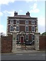
Old vicarage
Imposing building next to St Michaels Church.
Image: © John M
Taken: 9 Mar 2008
0.02 miles
8
Former National School
Opposite St Michaels Church.
Image: © John M
Taken: 9 Mar 2008
0.03 miles
9

The churchyard boundary wall, Madeley
Originally built in 1796, at the same time as the church, and presumably also designed by the county engineer Thomas Telford. The wall was Grade II listed https://www.britishlistedbuildings.co.uk/101033274-churchyard-boundary-wall-north-of-church-of-st-michael-madeley#.WuF1IvnwaM8 in 1983, and now also features the Image
Image: © Richard Law
Taken: 7 Apr 2018
0.03 miles