IMAGES TAKEN NEAR TO
Stokesay Fore, TELFORD, TF7 4QA
Introduction
This page details the photographs taken nearby to Stokesay Fore, TF7 4QA by members of the Geograph project.
The Geograph project started in 2005 with the aim of publishing, organising and preserving representative images for every square kilometre of Great Britain, Ireland and the Isle of Man.

There are currently over 7.5m images from over14,400 individuals and you can help contribute to the project by visiting https://www.geograph.org.uk
Image Map
Images are licensed for reuse under creativecommons.org/licenses/by-sa/2.0
Notes
- Clicking on the map will re-center to the selected point.
- The higher the marker number, the further away the image location is from the centre of the postcode.
Image Listing (8 Images Found)
Images are licensed for reuse under creativecommons.org/licenses/by-sa/2.0
Image
Details
Distance
1
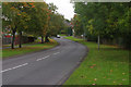
Sutton Way, Sutton Hill
Sutton Hill comprises a large 1960s housing estate surrounded by Sutton Way.
Image: © Stephen McKay
Taken: 10 Oct 2015
0.08 miles
2
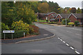
Great Hay Drive, Sutton Hill
Seen at the junction with Verbena Way with Carnoustie Drive leading off to the right.
Image: © Stephen McKay
Taken: 10 Oct 2015
0.13 miles
3
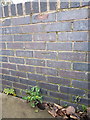
OS benchmark - Sutton Hill, subway bridge parapet
An OS cutmark on the parapet of a subway bridge under Sutton Way; originally levelled at 132.186m above Ordnance Datum Newlyn.
Image: © Richard Law
Taken: 15 Nov 2015
0.14 miles
5
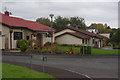
Punta Verde Drive, Sutton Hill
At the south end of Great Hay Drive is a small estate of highly unusual Spanish-style houses built by Tarmac in 1989. The name Punta Verde Drive emphasises the theme.
Image: © Stephen McKay
Taken: 10 Oct 2015
0.23 miles
6
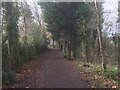
Path, Sutton Hill
A strip of woodland amongst the houses. Pre Telford mapping shows that this was once farmland.
Image: © Richard Webb
Taken: 8 Dec 2021
0.24 miles
7
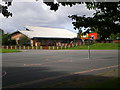
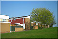
The Sir Alexander Fleming School
This school in the centre of Sutton Hill is named after the scientist who discovered penicillin.
Image: © Richard Law
Taken: 29 Aug 2009
0.24 miles
8
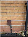
OS benchmark - Sutton Hill, 9 Smallwood
An OS cutmark on the rear of no 9 Smallwood (facing onto Sutton Way); originally levelled at 129.766m above Ordnance Datum Newlyn.
Image: © Richard Law
Taken: 15 Nov 2015
0.25 miles