IMAGES TAKEN NEAR TO
Halesfield 15, TELFORD, TF7 4ER
Introduction
This page details the photographs taken nearby to Halesfield 15, TF7 4ER by members of the Geograph project.
The Geograph project started in 2005 with the aim of publishing, organising and preserving representative images for every square kilometre of Great Britain, Ireland and the Isle of Man.

There are currently over 7.5m images from over14,400 individuals and you can help contribute to the project by visiting https://www.geograph.org.uk
Image Map
Images are licensed for reuse under creativecommons.org/licenses/by-sa/2.0
Notes
- Clicking on the map will re-center to the selected point.
- The higher the marker number, the further away the image location is from the centre of the postcode.
Image Listing (7 Images Found)
Images are licensed for reuse under creativecommons.org/licenses/by-sa/2.0
Image
Details
Distance
2
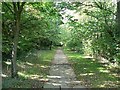
Path beside Halesfield 16
But hidden from the road on the right and factories on the left by the belts of trees and bushes.
Image: © Rich Tea
Taken: 26 Sep 2006
0.19 miles
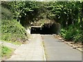
4
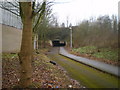
Underpass below the A442 Eastern Primary
A pedestrian/cycleway shared route, making for access from the northern side of Sutton Hill estate onto Halesfield 17.
Image: © Richard Law
Taken: 6 Feb 2010
0.20 miles
5
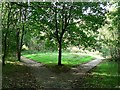
Where the path divides
Path on the south side of Halesfield 16
Image: © Rich Tea
Taken: 26 Sep 2006
0.22 miles
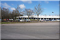
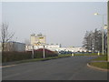
6
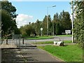
Halesfield 17 and Halesfield Roundabout
Roads round here are just given numbers.
Image: © Rich Tea
Taken: 26 Sep 2006
0.22 miles
7
Subway under Halesfield 16
Approaching along the path from the south.
Image: © Rich Tea
Taken: 26 Sep 2006
0.25 miles