IMAGES TAKEN NEAR TO
Bolas Heath, TELFORD, TF6 6PJ
Introduction
This page details the photographs taken nearby to TF6 6PJ by members of the Geograph project.
The Geograph project started in 2005 with the aim of publishing, organising and preserving representative images for every square kilometre of Great Britain, Ireland and the Isle of Man.

There are currently over 7.5m images from over14,400 individuals and you can help contribute to the project by visiting https://www.geograph.org.uk
Image Map (Loading...)


Getting Data...Please wait
Leaflet Map data © OpenStreetMap
Images are licensed for reuse under creativecommons.org/licenses/by-sa/2.0
Notes
- Clicking on the map will re-center to the selected point.
- The higher the marker number, the further away the image location is from the centre of the postcode.
Image Listing (6 Images Found)
Images are licensed for reuse under creativecommons.org/licenses/by-sa/2.0
Image
Details
Distance
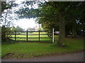
1

53 & 54 Bolas Heath
Semi-detached cottages on the lane between Ercall Heath and Great Bolas.
Image: © Richard Law
Taken: 11 Mar 2016
0.00 miles
3
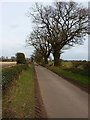
On the lane towards Ercall Heath
Large oaks in the hedge beside the lane suggest it's been here some good long while.
Image: © Richard Law
Taken: 11 Mar 2016
0.13 miles
5
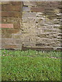
OS benchmark - Bolas Heath, former farm building at 52 Bolas Heath
An OS cutmark on the wall of an outbuilding on the south side of the road; originally levelled at 72.768m above Ordnance Datum Newlyn.
Image: © Richard Law
Taken: 11 Mar 2016
0.15 miles
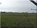
6
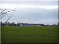
Common Farm
Taken from the lane leading up to Forest Farm
Image: © A Holmes
Taken: 31 Dec 2007
0.16 miles