IMAGES TAKEN NEAR TO
Waters Upton, TELFORD, TF6 6PA
Introduction
This page details the photographs taken nearby to TF6 6PA by members of the Geograph project.
The Geograph project started in 2005 with the aim of publishing, organising and preserving representative images for every square kilometre of Great Britain, Ireland and the Isle of Man.

There are currently over 7.5m images from over14,400 individuals and you can help contribute to the project by visiting https://www.geograph.org.uk
Image Map
Images are licensed for reuse under creativecommons.org/licenses/by-sa/2.0
Notes
- Clicking on the map will re-center to the selected point.
- The higher the marker number, the further away the image location is from the centre of the postcode.
Image Listing (5 Images Found)
Images are licensed for reuse under creativecommons.org/licenses/by-sa/2.0
Image
Details
Distance
2
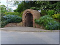
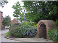
Waters Upton
A well looking by the sign post at Waters Upton.
Image: © A Holmes
Taken: 19 May 2007
0.15 miles
4
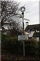
Old Direction Sign - Signpost in Waters Upton
Annulus finial - 4 arms; Shropshire CC modern halo by the UC road, in parish of Waters Upton (Telford and Wrekin District), Waters Upton junction with Catsbritch Lane.
Surveyed
Milestone Society National ID: SA_SJ6319
Image: © Milestone Society
Taken: Unknown
0.20 miles