IMAGES TAKEN NEAR TO
Tern Lane, TELFORD, TF6 6HZ
Introduction
This page details the photographs taken nearby to Tern Lane, TF6 6HZ by members of the Geograph project.
The Geograph project started in 2005 with the aim of publishing, organising and preserving representative images for every square kilometre of Great Britain, Ireland and the Isle of Man.

There are currently over 7.5m images from over14,400 individuals and you can help contribute to the project by visiting https://www.geograph.org.uk
Image Map (Loading...)


Getting Data...Please wait
Leaflet Map data © OpenStreetMap
Images are licensed for reuse under creativecommons.org/licenses/by-sa/2.0
Notes
- Clicking on the map will re-center to the selected point.
- The higher the marker number, the further away the image location is from the centre of the postcode.
Image Listing (5 Images Found)
Images are licensed for reuse under creativecommons.org/licenses/by-sa/2.0
Image
Details
Distance
1
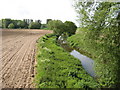
River Tern.
The river tern at Crudgington.
Image: © Paul Beaman
Taken: 20 May 2007
0.21 miles
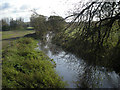
3
River Tern south of Crudgington Bridge
More or less the same photo as Image, taken at the other end of the year.
Image: © Richard Law
Taken: 5 Nov 2017
0.22 miles
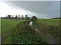
4
Concrete pad in corner of a field
Presumably the remains of some agricultural building or vehicle parking area in the field.
Image: © Richard Law
Taken: 5 Nov 2017
0.22 miles
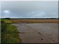
5
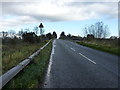
Crudgington Bridge
Seen from the west side of the B5062 to High Ercall, the bridge carries the road over the River Tern.
Image: © Richard Law
Taken: 5 Nov 2017
0.23 miles