IMAGES TAKEN NEAR TO
The Den, TELFORD, TF6 6EZ
Introduction
This page details the photographs taken nearby to The Den, TF6 6EZ by members of the Geograph project.
The Geograph project started in 2005 with the aim of publishing, organising and preserving representative images for every square kilometre of Great Britain, Ireland and the Isle of Man.

There are currently over 7.5m images from over14,400 individuals and you can help contribute to the project by visiting https://www.geograph.org.uk
Image Map (Loading...)


Getting Data...Please wait
Leaflet Map data © OpenStreetMap
Images are licensed for reuse under creativecommons.org/licenses/by-sa/2.0
Notes
- Clicking on the map will re-center to the selected point.
- The higher the marker number, the further away the image location is from the centre of the postcode.
Image Listing (4 Images Found)
Images are licensed for reuse under creativecommons.org/licenses/by-sa/2.0
Image
Details
Distance
2
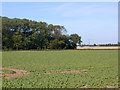
Farmland and wood.
Looking north from the minor road, this shows a field of sugar beet (a common crop in the area), with a chicken farm in the distance. The woodland is Wheelwright Covert, which suggests an earlier use for the timber.
Image: © Bob Bowyer
Taken: 23 Sep 2005
0.18 miles
3
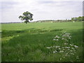
Tree in a field
Traffic can be seen speeding along the A442.
Image: © Row17
Taken: 20 May 2008
0.19 miles