IMAGES TAKEN NEAR TO
Kynnersley, TELFORD, TF6 6DZ
Introduction
This page details the photographs taken nearby to TF6 6DZ by members of the Geograph project.
The Geograph project started in 2005 with the aim of publishing, organising and preserving representative images for every square kilometre of Great Britain, Ireland and the Isle of Man.

There are currently over 7.5m images from over14,400 individuals and you can help contribute to the project by visiting https://www.geograph.org.uk
Image Map (Loading...)


Getting Data...Please wait
Leaflet Map data © OpenStreetMap
Images are licensed for reuse under creativecommons.org/licenses/by-sa/2.0
Notes
- Clicking on the map will re-center to the selected point.
- The higher the marker number, the further away the image location is from the centre of the postcode.
Image Listing (19 Images Found)
Images are licensed for reuse under creativecommons.org/licenses/by-sa/2.0
Image
Details
Distance
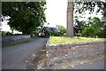
2
Old Direction Sign - Signpost in Kynnersley
Annulus finial - 2 arms; Shropshire CC modern halo by the UC road, in parish of Kynnersley (Telford and Wrekin District).
Surveyed
Milestone Society National ID: SA_SJ6716
Image: © Milestone Society
Taken: Unknown
0.07 miles
3
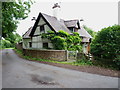
Whym Cottage in Kynnersley
A 17th century, half-timbered Grade II listed https://www.britishlistedbuildings.co.uk/101374542-whym-cottage-kynnersley#.WVTjc4QrKM8 building, the listing being granted in 1983. The main part of the house holds the main historical interest, whilst the brick extension to the rear (half see to the left here) is 18th century.
Image: © Richard Law
Taken: 10 Jun 2017
0.07 miles
4
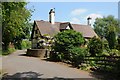
Timber-framed cottage in Kynnersley
Timber-framed cottage opposite Kynnersley church. This cottage has previously been photographed in 2007 Image
Image: © Philip Halling
Taken: 19 May 2018
0.07 miles
5
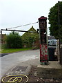
Old diesel pump in Kynnersley
Right outside the wall of Kynnersley Manor house farm, this old pump presumably dispensed diesel to the farm vehicles before falling into disuse.
Image: © Richard Law
Taken: 10 Jun 2017
0.08 miles
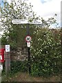
6

Road junction in Kynnersley
An unusual grass triangle junction - this one's 4' above ground and surrounded by a protective wall.
Image: © Richard Law
Taken: 17 May 2015
0.08 miles
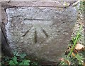
7
OS benchmark - Kynnersley, St Chad's church
An OS cutmark on the NE face of the church; originally levelled at 60.46m above Ordnance Datum Newlyn.
Image: © Richard Law
Taken: 17 May 2015
0.09 miles
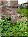
8
Ordnance Survey Cut Mark
This OS cut mark can be found on the NE face of St Chad's Church. It marks a point 60.460m above mean sea level.
Image: © Adrian Dust
Taken: 30 Sep 2016
0.10 miles
9
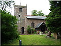
St Chad's church in Kynnersley
The village church of St Chad's holds a Grade II* listing https://www.britishlistedbuildings.co.uk/101374541-church-of-st-chad-kynnersley#.WVTlpYQrKM8 granted as early as 1959. The chancel dates back to the 14th century, although the tower is more like early 18th century, and the interior was re-furbished in Victorian times.
Image: © Richard Law
Taken: 10 Jun 2017
0.11 miles
10
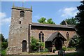
Kynnersley church
Kynnersley church is dedicated to St Chad. Though originally medieval, the nave was rebuilt in the 19th century and the tower dates from 1722-3. The church is Grade II* listed, see: https://historicengland.org.uk/listing/the-list/list-entry/1374541
Image: © Philip Halling
Taken: 19 May 2018
0.11 miles