IMAGES TAKEN NEAR TO
Wheathill, Uppington, TELFORD, TF6 5HQ
Introduction
This page details the photographs taken nearby to TF6 5HQ by members of the Geograph project.
The Geograph project started in 2005 with the aim of publishing, organising and preserving representative images for every square kilometre of Great Britain, Ireland and the Isle of Man.

There are currently over 7.5m images from over14,400 individuals and you can help contribute to the project by visiting https://www.geograph.org.uk
Image Map (Loading...)


Getting Data...Please wait
Leaflet Map data © OpenStreetMap
Images are licensed for reuse under creativecommons.org/licenses/by-sa/2.0
Notes
- Clicking on the map will re-center to the selected point.
- The higher the marker number, the further away the image location is from the centre of the postcode.
Image Listing (4 Images Found)
Images are licensed for reuse under creativecommons.org/licenses/by-sa/2.0
Image
Details
Distance
3
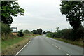
Looking along Watling Street towards Wales from the Uppington Junction
Image: © Mick Malpass
Taken: 8 May 2012
0.24 miles
4
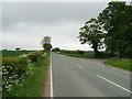
B5061 towards Wellington
Looking north east on Watling Street at the junction with the road to Uppington.
Image: © JThomas
Taken: 18 May 2019
0.25 miles