
IMAGES TAKEN NEAR TO
New Works, TELFORD, TF6 5BP
Introduction
This page details the photographs taken nearby to TF6 5BP by members of the Geograph project.
The Geograph project started in 2005 with the aim of publishing, organising and preserving representative images for every square kilometre of Great Britain, Ireland and the Isle of Man.

There are currently over 7.5m images from over14,400 individuals and you can help contribute to the project by visiting https://www.geograph.org.uk
Image Map
Images are licensed for reuse under creativecommons.org/licenses/by-sa/2.0
Notes
- Clicking on the map will re-center to the selected point.
- The higher the marker number, the further away the image location is from the centre of the postcode.
Image Listing (12 Images Found)
Images are licensed for reuse under creativecommons.org/licenses/by-sa/2.0
Image
Details
Distance
1
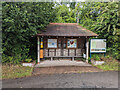
Bus Shelter in New Works village
Adjacent is an info board about the village:
"The hamlet of New Works lies in the north-east corner of the ancient parish of Little Wenlock that extended from the foot of the Wrekin almost to the banks of the River Severn. As its name implies, this was the new area of mining developed by the Darbys in the 18th century to supply coal and iron ore to their furnace at Coalbrookdale. But in the area to the north of the hamlet and to the west of New Works are the remains of small bell-pits and evidence of working going back at least 500 years; and this area has been scheduled as an Ancient Monument site.
"After the village of Little Wenlock itself, New Works became the most populous settlement of the parish. It attained its fullest extent by 1798, with miners and workers cottages straddled along both sides of the southern end of New Works Lane. This lane - an ancient 'hundred boundary' bordering the land granted to St Milburga in the late 7th century by the Mercian Kings - forms the western boundary of the parish's northern arm and seems to have been part of the route from Much Wenlock, via Buildwas, to Arleston and Watling Street.
"In the northern arm of the parish, an ironworks was established in 1822, taken over by the Coalbrookdale Company in 1847 and closed about 1870. The course of the tramway that conveyed limestone from Steeraway and coal from the Shortwood can still be traced. Although most mining had ceased by the end of the 19th century, Lawley Furnaces colliery remained open until 1937 and opencast mining was carried on in the area after the Second World War.
"The walks and pathways in and around the hamlet provide an opportunity to experience and savour the wonderful landscape, flora and fauna. The bluebells of Short Wood in the full bloom of springtime are worthy of a memorable visit."
Image: © TCExplorer
Taken: 19 Jul 2023
0.04 miles
2

Road junction at New Works
This junction has a lane that leads to Huntington and Little Wenlock.
Image: © A Holmes
Taken: 1 Jul 2007
0.05 miles


5

New Works Lane
New Works, a small village within the Telford boundary.
Image: © Phil Child
Taken: 5 Mar 2017
0.10 miles

7
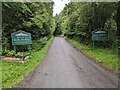
Village signs at the entrance to New Works village
Attractive village signs, erected sometime between 2009 and 2016
Image: © TCExplorer
Taken: 19 Jul 2023
0.14 miles
8

Footpath entrance by New Works
The first section is shared with a track
Image: © TCExplorer
Taken: 19 Jul 2023
0.15 miles
9
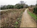
The trudge
The Wrekin Trundle is a planned multi-user rural trail for walkers, horse riders, cyclists and runners. It will give high priority to disabled access with suitable parking, a bench walk and picnic spaces.
Image: © Phil Child
Taken: 5 Mar 2017
0.17 miles
10
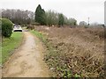
The Trundle, New Works, Telford
The Wrekin Trundle is a planned multi-user rural trail for walkers, horse riders, cyclists and runners. It will give high priority to disabled access with suitable parking, a bench walk and picnic spaces.
Image: © Phil Child
Taken: 5 Mar 2017
0.17 miles