IMAGES TAKEN NEAR TO
Lintin Close, TELFORD, TF5 0DS
Introduction
This page details the photographs taken nearby to Lintin Close, TF5 0DS by members of the Geograph project.
The Geograph project started in 2005 with the aim of publishing, organising and preserving representative images for every square kilometre of Great Britain, Ireland and the Isle of Man.

There are currently over 7.5m images from over14,400 individuals and you can help contribute to the project by visiting https://www.geograph.org.uk
Image Map
Images are licensed for reuse under creativecommons.org/licenses/by-sa/2.0
Notes
- Clicking on the map will re-center to the selected point.
- The higher the marker number, the further away the image location is from the centre of the postcode.
Image Listing (5 Images Found)
Images are licensed for reuse under creativecommons.org/licenses/by-sa/2.0
Image
Details
Distance
1
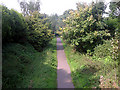
The Silkin Way
This is part of the footpath/cycleway that runs across Telford from the River Severn at Coalport to Bratton on the northern edge of the town.
Image: © Row17
Taken: 26 Sep 2008
0.15 miles
2
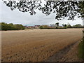
New-build housing at Admaston
4 & 5-bed houses recently built at Admaston Farm
Image: © Richard Law
Taken: 8 Oct 2011
0.16 miles
3
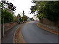
Admaston street scene
On Bratton Road, looking towards the junction with Elmsdale Crescent
Image: © Richard Law
Taken: 8 Oct 2011
0.21 miles
4
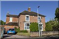
Admaston Village
Feriehurst House in Admaston village
Image: © P Gaskell
Taken: Unknown
0.22 miles