IMAGES TAKEN NEAR TO
Sandstone Close, TF4 3XG
Introduction
This page details the photographs taken nearby to Sandstone Close, TF4 3XG by members of the Geograph project.
The Geograph project started in 2005 with the aim of publishing, organising and preserving representative images for every square kilometre of Great Britain, Ireland and the Isle of Man.

There are currently over 7.5m images from over14,400 individuals and you can help contribute to the project by visiting https://www.geograph.org.uk
Image Map (Loading...)


Getting Data...Please wait
Leaflet Map data © OpenStreetMap
Images are licensed for reuse under creativecommons.org/licenses/by-sa/2.0
Notes
- Clicking on the map will re-center to the selected point.
- The higher the marker number, the further away the image location is from the centre of the postcode.
Image Listing (2 Images Found)
Images are licensed for reuse under creativecommons.org/licenses/by-sa/2.0
Image
Details
Distance
1
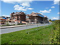
Housing development - Lightmoor
Telford's development continues apace. In this case, it's the building of a 'community village', sponsored by the Bournville Village Trust, which aims to create a community in the Lightmoor area with a 'village feel' to it. A new school is being built at the same time as the housing, along with open spaces, wooded areas, and small pools.
Image: © Richard Law
Taken: 9 May 2010
0.11 miles
2
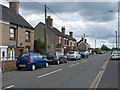
Wellington Road, Horsehay, Telford
This straight old road is now bypassed on the way from Wellington to Jiggers Bank and Coalbrookdale. The cottages along it pre-date the present elevated road surface and a railing has been erected to prevent folk falling off the road onto the pavement.
Image: © Mike White
Taken: 13 Jul 2008
0.25 miles