IMAGES TAKEN NEAR TO
New Road, TELFORD, TF4 3LJ
Introduction
This page details the photographs taken nearby to New Road, TF4 3LJ by members of the Geograph project.
The Geograph project started in 2005 with the aim of publishing, organising and preserving representative images for every square kilometre of Great Britain, Ireland and the Isle of Man.

There are currently over 7.5m images from over14,400 individuals and you can help contribute to the project by visiting https://www.geograph.org.uk
Image Map (Loading...)


Getting Data...Please wait
Leaflet Map data © OpenStreetMap
Images are licensed for reuse under creativecommons.org/licenses/by-sa/2.0
Notes
- Clicking on the map will re-center to the selected point.
- The higher the marker number, the further away the image location is from the centre of the postcode.
Image Listing (13 Images Found)
Images are licensed for reuse under creativecommons.org/licenses/by-sa/2.0
Image
Details
Distance
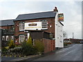
1
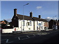
The White Horse, Dawley, Telford and Wrekin
Former Greenalls pub.
Image: © al partington
Taken: 6 Feb 2008
0.08 miles
3
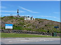
Dawleywood!
Signage erected by a local wag on the side of Paddock Mound, Dawley. The lettering has become quite a local landmark.
Image: © Richard Law
Taken: 20 Jun 2010
0.12 miles
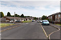
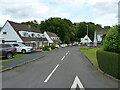
4
Crown Street, Dawley
View WNW along Crown Street.
Image: © David P Howard
Taken: 1 Jul 2015
0.15 miles
5
Crown Street, Dawley
View ESE along Crown Street.
Image: © David P Howard
Taken: 1 Jul 2015
0.16 miles
6
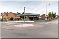
Hand car wash
This former filling station on the corner of Finger Road and Hinkshay Road has now become a hand car wash, like so many others have done.
For an earlier image see Image
Image: © David P Howard
Taken: 1 Jul 2015
0.16 miles
7
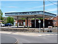
Former petrol station, Dawley
I can't remember which of the petrol companies this one was operated by, but what caught my eye was the graffiti. I understand the strength of feeling about the protests against proposed open-cast mining on the nearby Wrekin, but at least have the nous to spell 'MINING' correctly!
Image: © Richard Law
Taken: 20 Jun 2010
0.17 miles
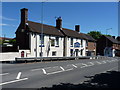
8
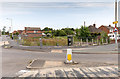
Site of the former Queen's Arms
Looking north east across Southall Road towards the site on the corner of Hinkshay Road and Rowan Avenue which used to be occupied by The Queen's Arms public house but has now been demolished.
For an image of the pub see Image
Image: © David P Howard
Taken: 1 Jul 2015
0.18 miles
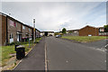
10
Magna Close in Dawley
1970s 'chalet' style housing on Magna Close
Image: © Richard Law
Taken: 5 Jun 2021
0.20 miles