IMAGES TAKEN NEAR TO
Southview Road, TELFORD, TF4 3HS
Introduction
This page details the photographs taken nearby to Southview Road, TF4 3HS by members of the Geograph project.
The Geograph project started in 2005 with the aim of publishing, organising and preserving representative images for every square kilometre of Great Britain, Ireland and the Isle of Man.

There are currently over 7.5m images from over14,400 individuals and you can help contribute to the project by visiting https://www.geograph.org.uk
Image Map (Loading...)


Getting Data...Please wait
Leaflet Map data © OpenStreetMap
Images are licensed for reuse under creativecommons.org/licenses/by-sa/2.0
Notes
- Clicking on the map will re-center to the selected point.
- The higher the marker number, the further away the image location is from the centre of the postcode.
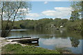
Image Listing (18 Images Found)
Images are licensed for reuse under creativecommons.org/licenses/by-sa/2.0
Image
Details
Distance
1
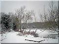
Little Dawley, Lower Balancing Pool in winter
Image: © Row17
Taken: 13 Jan 2010
0.07 miles


6
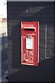
George VI postbox on Holly Road, Little Dawley
Image: © Ian S
Taken: 31 Mar 2016
0.12 miles
9

Wesleyan Chapel on Holly Road, Little Dawley
Built in 1837.
Image: © Ian S
Taken: 31 Mar 2016
0.15 miles
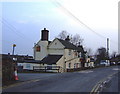
10
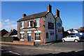
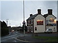
The Unicorn on Holly Road, Little Dawley
http://www.geograph.org.uk/photo/4897741
Image: © Ian S
Taken: 31 Mar 2016
0.15 miles