IMAGES TAKEN NEAR TO
Woodhouse Lane, TELFORD, TF4 3BJ
Introduction
This page details the photographs taken nearby to Woodhouse Lane, TF4 3BJ by members of the Geograph project.
The Geograph project started in 2005 with the aim of publishing, organising and preserving representative images for every square kilometre of Great Britain, Ireland and the Isle of Man.

There are currently over 7.5m images from over14,400 individuals and you can help contribute to the project by visiting https://www.geograph.org.uk
Image Map
Images are licensed for reuse under creativecommons.org/licenses/by-sa/2.0
Notes
- Clicking on the map will re-center to the selected point.
- The higher the marker number, the further away the image location is from the centre of the postcode.
Image Listing (56 Images Found)
Images are licensed for reuse under creativecommons.org/licenses/by-sa/2.0
Image
Details
Distance
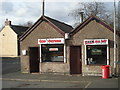
1
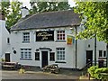
The Travellers Joy, Horsehay
Another pub to let, well off the beaten track. There simply aren't the local drinkers to keep these pubs alive, and passing trade is negligible.
Image: © Mike White
Taken: 29 Jul 2008
0.01 miles
2
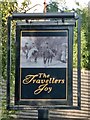
The Travellers Joy
The sign's faded and the pub's to let.
Image: © Mike White
Taken: 29 Jul 2008
0.02 miles
3
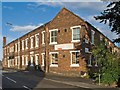
Horsehay Works Offices
These buildings, and the old staff canteen across the road (now Horsehay Village Hall) are what remains of the Horsehay Works of the Coalbrookdale Company.
Image: © Mike White
Taken: 29 Jul 2008
0.06 miles
4
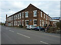
Horsehay Works Offices, Dawley
Built around 1830 as the administrative offices for the nearby Horsehay Ironworks, which was part of the much larger Coalbrookdale Company Ironworks division; they were Grade II listed https://britishlistedbuildings.co.uk/101367386-horsehay-works-offices-dawley-hamlets#.YGePFuhKjIU & https://historicengland.org.uk/listing/the-list/list-entry/1367386 in 1968, and have fairly recently been converted to flats.
Image: © Richard Law
Taken: 6 Mar 2021
0.09 miles
5
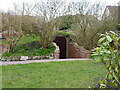
Anderson Shelter in the garden of a house
On the corner of Bridge Road and Farm Lane lies this remnant of the 2nd World War; it's an underground Anderson (bomb) Shelter, the roof of which has been made into something of a pot-plant feature by the residents, and appears to be in use as a kind of garden shed.
Image: © Richard Law
Taken: 6 Mar 2021
0.10 miles
7
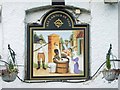
All Labour in Vain
When I first saw this picture of miners, in the home of the Industrial Revolution, scrubbing away in vain, I was shocked. It still bothers me a bit.
Image: © Mike White
Taken: 29 Jul 2008
0.13 miles
8
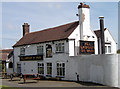
All Labour in Vain, Horsehay
The All Labour in Vain inn at Horsehay, has a 'non PC' sign that has been the subject of a number of protests. See Mike White's photo-- Image
Image: © Gordon Cragg
Taken: Unknown
0.13 miles
9
The Labour In Vain
A curious name for a pub, and a curious way of spelling Sunday Lunches...
Image: © Steve McShane
Taken: 15 Apr 2006
0.15 miles
10
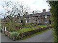
Old Row Cottages
A long row of 15 brick-built cottages, dating from the mid 18th century, which were built by the nearby Horsehay Ironworks (part of the Coalbrookdale Company) to house workers at the foundry. Collectively Grade II listed https://britishlistedbuildings.co.uk/101054169-old-row-cottages-dawley-hamlets#.YGTtiOhKjIU & https://historicengland.org.uk/listing/the-list/list-entry/1054169 in 1968. A little further up the road there is a similar line, called Image
Image: © Richard Law
Taken: 6 Mar 2021
0.16 miles