IMAGES TAKEN NEAR TO
Pool Hill Road, TELFORD, TF4 3AU
Introduction
This page details the photographs taken nearby to Pool Hill Road, TF4 3AU by members of the Geograph project.
The Geograph project started in 2005 with the aim of publishing, organising and preserving representative images for every square kilometre of Great Britain, Ireland and the Isle of Man.

There are currently over 7.5m images from over14,400 individuals and you can help contribute to the project by visiting https://www.geograph.org.uk
Image Map
Images are licensed for reuse under creativecommons.org/licenses/by-sa/2.0
Notes
- Clicking on the map will re-center to the selected point.
- The higher the marker number, the further away the image location is from the centre of the postcode.
Image Listing (64 Images Found)
Images are licensed for reuse under creativecommons.org/licenses/by-sa/2.0
Image
Details
Distance
1
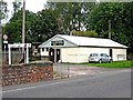
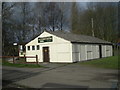
Model railway & tea rooms, Fence Road
Railway House is the home of Telford Steam Railway's model railway exhibition. On its left is the Furnaces Tea Rooms. Both these can be accessed from the nearby Bridge Road, or by taking the path up from the platform of the adjacent Horsehay & Dawley Railway Station.
Image: © L S Wilson
Taken: 5 Sep 2010
0.04 miles
2
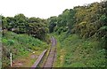
Telford Steam Railway - the line to Doseley Halt & Lightmoor
Photographed from the bridge over Horsehay & Dawley Railway Station, part of which can be seen in this view. The line in this direction is already constructed for much of the way to Doseley Halt, as it was required for works trains to remove spoil from the northern extension to Lawley Common. However, in the direction to Doseley Halt, the track it is not yet up to the standard required to run passenger services.
Going beyond the halt to Lightmoor, requires legal powers to cross a public road, and of course the money to finance the extension. If this happens, then the line will eventually be re-instated, where it is shown in this photo by Row17:- Image
Longer term, there are hopes that the line could eventually cross the River Severn and terminate at Buildwas. However there are lots of things that need to happen before that could become a reality.
Image
Image
Image: © P L Chadwick
Taken: 5 Sep 2010
0.04 miles
3
You won't find this in any Network Rail guide
Image: © Row17
Taken: 27 Feb 2008
0.05 miles
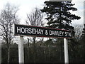
4
Railway bridge & platform
Horsehay station.
Image: © Ray Durrant
Taken: 15 Aug 1980
0.06 miles
5
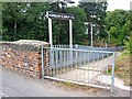
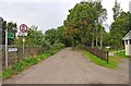
Footpath from Bridge Road to Horsehay & Dawley Railway Station, Telford Steam Railway
The footpath leads down to the station platform, which is at a much lower level than the road.
Image
Image
Image: © L S Wilson
Taken: 5 Sep 2010
0.06 miles
6
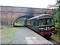
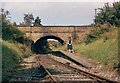
Telford Steam Railway - Horsehay & Dawley Railway Station and bridge
There's not much left to see at this railway station, but you can visit the nearby model railway exhibition, or the Furnaces Tea Rooms. Image
The line ahead goes in the direction of Doseley Halt, but it's not open to passenger traffic at present. The bridge carries Bridge Road across the railway. For details of the DMU no. 50479, standing at the station, please see:- Image
Image
Image: © L S Wilson
Taken: 5 Sep 2010
0.06 miles
8
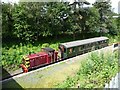
Train at Horsehay & Dawlish station
Operated by the Telford Steam Railway.
Image: © Christine Johnstone
Taken: 8 Jul 2012
0.07 miles
9
Fence Road
This road is a restricted byway. It is part of the Ironbridge Way, and leads to Heath Hill in half a mile. At this point, Fence Road is adjacent to Horsehay and Dawley Railway Station, on the Telford Steam Railway, although that is at a much lower level.
Image: © P L Chadwick
Taken: 5 Sep 2010
0.07 miles
10
Telford steam railway
see their web site for more details http://www.telfordsteamrailway.co.uk/index.shtml
Image: © David Bagshaw
Taken: 17 Jan 2006
0.07 miles