
IMAGES TAKEN NEAR TO
Calverhall, TELFORD, TF3 1YB
Introduction
This page details the photographs taken nearby to Calverhall, TF3 1YB by members of the Geograph project.
The Geograph project started in 2005 with the aim of publishing, organising and preserving representative images for every square kilometre of Great Britain, Ireland and the Isle of Man.

There are currently over 7.5m images from over14,400 individuals and you can help contribute to the project by visiting https://www.geograph.org.uk
Image Map
Images are licensed for reuse under creativecommons.org/licenses/by-sa/2.0
Notes
- Clicking on the map will re-center to the selected point.
- The higher the marker number, the further away the image location is from the centre of the postcode.
Image Listing (14 Images Found)
Images are licensed for reuse under creativecommons.org/licenses/by-sa/2.0
Image
Details
Distance
1
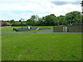
Play area at the back of Stirchley housing estate
A small playpark for young children at the rear of a large housing estate in the Stirchley area of Telford.
Image: © Richard Law
Taken: 5 Jun 2021
0.10 miles
2
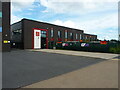
Grange Park Primary school, Stirchley
Located just adjacent to Image, and presumably a 'feeder' school for that establishment.
Image: © Richard Law
Taken: 5 Jun 2021
0.11 miles
3

Telford Park School, Stirchley
Telford Park School moved into these buildings around the beginning of the 2015 academic year, having previously been The Lord Silkin School (Minister for New Towns in the 1960s) and later the Lakeside Academy.
Image: © Richard Law
Taken: 5 Jun 2021
0.11 miles
4
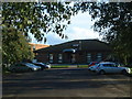
Stirchley Day Centre
Local centre offering facilities for disabled and the elderly to enjoy their afternoons.
Image: © Steve McShane
Taken: 12 Nov 2005
0.16 miles
5

Five-A-Side!
The sports hall section of Stirchley Recreation Centre, taken from its car park.
Image: © Steve McShane
Taken: 12 Nov 2005
0.16 miles
7
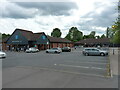
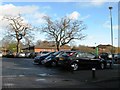
Co-op supermarket, Stirchley
The Co-op occupies the nearest building, with a couple of takeaway businesses and the like in the unit at the far side of the carpark.
Image: © Richard Law
Taken: 5 Jun 2021
0.19 miles
8

Pool at the Stirchley Dingle Local Nature Reserve
Image: © Mat Fascione
Taken: 15 Sep 2023
0.20 miles
9

Stirchley Recreation Centre
View of the entrance (complete with new corporate signing) to the Sports Centre. It acts as the sports area for the adjoining school, Lord Silkin.
Image: © Steve McShane
Taken: 12 Nov 2005
0.20 miles
10

Tennis Courts
Stirchley Recreation Centre run these tennis courts. Behind the tarmac area is the rugby pitch, where the local rugby league team train and play.
This picture is taken on a cool November day, and the sun was very low...
Image: © Steve McShane
Taken: 12 Nov 2005
0.24 miles