IMAGES TAKEN NEAR TO
Cookson Close, TELFORD, TF2 8SZ
Introduction
This page details the photographs taken nearby to Cookson Close, TF2 8SZ by members of the Geograph project.
The Geograph project started in 2005 with the aim of publishing, organising and preserving representative images for every square kilometre of Great Britain, Ireland and the Isle of Man.

There are currently over 7.5m images from over14,400 individuals and you can help contribute to the project by visiting https://www.geograph.org.uk
Image Map
Images are licensed for reuse under creativecommons.org/licenses/by-sa/2.0
Notes
- Clicking on the map will re-center to the selected point.
- The higher the marker number, the further away the image location is from the centre of the postcode.
Image Listing (6 Images Found)
Images are licensed for reuse under creativecommons.org/licenses/by-sa/2.0
Image
Details
Distance
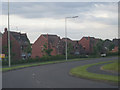
1
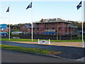
New-build housing at Muxton - Regent's Crescent
Image: © Richard Law
Taken: 9 Dec 2011
0.13 miles
3
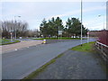
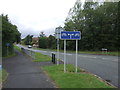
Donnington Wood roundabout
On the B5060, between Muxton and the main part of Donnington Wood.
Image: © Richard Law
Taken: 14 Jan 2017
0.17 miles
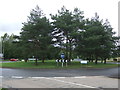
5
Cycle path beside Celandine Way, Donnington
Image: © JThomas
Taken: 10 Aug 2019
0.20 miles
6
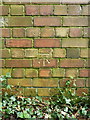
OS benchmark - Muxton Grange
A clear OS cutmark on a derelict mine building in the woods near the Granville Country Park; originally levelled at 97.542 above Ordnance Datum Newlyn.
Image: © Richard Law
Taken: 13 Sep 2014
0.24 miles