IMAGES TAKEN NEAR TO
Wellington Road, TELFORD, TF2 8NG
Introduction
This page details the photographs taken nearby to Wellington Road, TF2 8NG by members of the Geograph project.
The Geograph project started in 2005 with the aim of publishing, organising and preserving representative images for every square kilometre of Great Britain, Ireland and the Isle of Man.

There are currently over 7.5m images from over14,400 individuals and you can help contribute to the project by visiting https://www.geograph.org.uk
Image Map
Images are licensed for reuse under creativecommons.org/licenses/by-sa/2.0
Notes
- Clicking on the map will re-center to the selected point.
- The higher the marker number, the further away the image location is from the centre of the postcode.
Image Listing (27 Images Found)
Images are licensed for reuse under creativecommons.org/licenses/by-sa/2.0
Image
Details
Distance
1
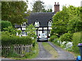
31-35 Wellington Road, Muxton
The row of cottages in view here dates originally from the 17th century, although the 4 dormers (one's hidden by the tree on the right) were added in the 19th. The whole group was collectively Grade II listed https://britishlistedbuildings.co.uk/101355194-31-35-wellington-road-donnington-and-muxton#.YNuEGehKhPY & https://historicengland.org.uk/listing/the-list/list-entry/1355194 in 1983.
Image: © Richard Law
Taken: 12 May 2020
0.04 miles
2
24 - 28 Wellington Road, Muxton
The timber framed part of this row dates from the 17th century, with the 3 dormers added in the 19th century. It was Grade II listed https://britishlistedbuildings.co.uk/101025008-24-28-wellington-road-donnington-and-muxton#.YNuFcOhKhPY & https://historicengland.org.uk/listing/the-list/list-entry/1025008 in 1983. I believe the smaller (brick) cottage on the left is not included in the listing.
Image: © Richard Law
Taken: 12 May 2020
0.05 miles
3
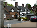
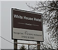
The White House Hotel
On Wellington Road, Muxton. http://www.geograph.org.uk/photo/4893027
Image: © Ian S
Taken: 29 Mar 2016
0.07 miles
4
The White House Hotel
On Wellington Road, Muxton. http://www.geograph.org.uk/photo/4893024
Image: © Ian S
Taken: 29 Mar 2016
0.09 miles
5
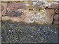
Ordnance Survey Cut Mark
This OS cut mark can be found on the wall of the White House Hotel. It marks a point 75.043m above mean sea level.
Image: © Adrian Dust
Taken: 23 Nov 2022
0.09 miles
6
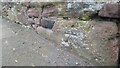
White House Roadside Wall
The slightly eroded cut benchmark within the roadside wall between Wellington Road and the White House carpark
Image: © Anthony Rowley
Taken: 7 Apr 2021
0.09 miles
7
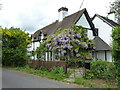
Vicarage of St Matthew's church
A substantial 17th century timber framed house, Grade II listed https://britishlistedbuildings.co.uk/101054180 https://historicengland.org.uk/listing/the-list/list-entry/1054180 in 1983. It was named at that point as the Vicarage of St Matthew's, but the nearest church of that name is in Donnington Wood Image, roughly a mile south of here; it seems unlikely to be that one.
Image: © Richard Law
Taken: 12 May 2020
0.10 miles
8
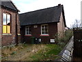
The old Sunday School building at Muxton
The foundation stones show 1884, and the engraving between the windows mentions 1894, which effectively give us a date that the Sunday School was first in operation here.
Image: © Richard Law
Taken: 18 Feb 2012
0.11 miles
9
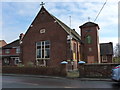
The (former?) Methodist Church in Muxton
Although still apparently used as a church on occasions, the sign above the door in the tower appeared to be written in Polish or a similar middle-European language, so I suspect the church is no longer Methodist.
Image: © Richard Law
Taken: 18 Feb 2012
0.11 miles
10
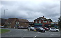
Post Office and shops on Wellington Road, Muxton
Image: © JThomas
Taken: 10 Aug 2019
0.12 miles