IMAGES TAKEN NEAR TO
Woodhouse Crescent, TELFORD, TF2 7HA
Introduction
This page details the photographs taken nearby to Woodhouse Crescent, TF2 7HA by members of the Geograph project.
The Geograph project started in 2005 with the aim of publishing, organising and preserving representative images for every square kilometre of Great Britain, Ireland and the Isle of Man.

There are currently over 7.5m images from over14,400 individuals and you can help contribute to the project by visiting https://www.geograph.org.uk
Image Map
Images are licensed for reuse under creativecommons.org/licenses/by-sa/2.0
Notes
- Clicking on the map will re-center to the selected point.
- The higher the marker number, the further away the image location is from the centre of the postcode.
Image Listing (10 Images Found)
Images are licensed for reuse under creativecommons.org/licenses/by-sa/2.0
Image
Details
Distance
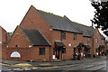
1
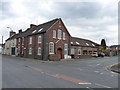
The Bethesda Primitive Methodist Chapel, Trench
Built in 1835, according to the rather poorly-preserved stone in the gable end. It does now look as if it's a private residence.
Image: © Richard Law
Taken: 12 Mar 2011
0.09 miles
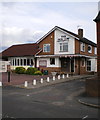
2
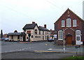
Duke of York, Trench
Former Greenalls pub now selling Banks's and Marstons beers
Image: © al partington
Taken: 15 Mar 2006
0.10 miles
3
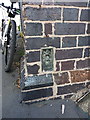
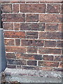
OS flush bracket G9620 - Trench
A Flush Bracket mounted in the wall of the former Image (on the corner nearest the camera in that photo). It was installed in 1958, and levelled at 79.136m above Ordnance Datum Newlyn.
Image: © Richard Law
Taken: 10 Aug 2014
0.12 miles
4
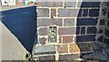
Bethesda Chapel Flush Bracket Benchmark
The OS Flush Bracket that is sited on the former Methodist Non-conformity chapel. The Flush Bracket was last verified by OS in 1958. It is 0.4-metres above the ground and 79.14-metres above the Newlyn datum.
Bethesda Chapel was opened 4th November 1866. It is now a residential building.
Image: © Anthony Rowley
Taken: 7 Sep 2021
0.12 miles
5
Friendly locals at The Dun Cow
Your photographer gets a cheery wave from two customers sitting outside this pub on Trench Road.
Image: © Richard Law
Taken: 1 Jul 2012
0.13 miles
6
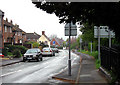
Church Road, Wrockwardine Wood, Telford
Church Road, Wrockwardine Wood, Telford looking North, from the side of the churchyard.
Image: © Gordon Cragg
Taken: 16 Apr 2009
0.14 miles
7
The Curse of the Wheelie Bin!
What could be an attractive street scene, at this recent development at Church Road, Wrockwardine Wood, Telford, is blighted by the accursed wheelie bins.
Why,Oh,Why do they not make provision for the storage of these bins when they design new property?
Image: © Gordon Cragg
Taken: 16 Apr 2009
0.21 miles
8
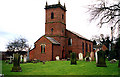
Holy Trinity Church, Wrockwardine Wood, Telford
Holy Trinity Church.
Image: © Gordon Cragg
Taken: 10 May 2003
0.22 miles
9
OS benchmark - Trench, Holy Trinity Church
An OS cutmark on the wall of the church; originally levelled at 99.389m above Ordnance Datum Newlyn.
Image: © Richard Law
Taken: 10 Aug 2014
0.24 miles
10
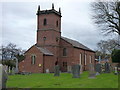
Holy Trinity Church, Wrockwardine Wood
Built in 1833 by an architect from Madeley, and Grade II listed https://britishlistedbuildings.co.uk/101351998-holy-trinity-church-wrockwardine-wood-and-trench#.XBvJk9SLTGg in 1983.
Image: © Richard Law
Taken: 20 Dec 2018
0.24 miles