IMAGES TAKEN NEAR TO
Bowling Green Close, TELFORD, TF2 6FD
Introduction
This page details the photographs taken nearby to Bowling Green Close, TF2 6FD by members of the Geograph project.
The Geograph project started in 2005 with the aim of publishing, organising and preserving representative images for every square kilometre of Great Britain, Ireland and the Isle of Man.

There are currently over 7.5m images from over14,400 individuals and you can help contribute to the project by visiting https://www.geograph.org.uk
Image Map
Images are licensed for reuse under creativecommons.org/licenses/by-sa/2.0
Notes
- Clicking on the map will re-center to the selected point.
- The higher the marker number, the further away the image location is from the centre of the postcode.
Image Listing (263 Images Found)
Images are licensed for reuse under creativecommons.org/licenses/by-sa/2.0
Image
Details
Distance
1
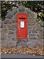
Postbox on the old A5, Ketley
Must be George V, because if it was George VI, the number would be shown.
Image: © Mike White
Taken: 26 Oct 2008
0.04 miles
2
Milepost
Old castiron milepost on what was the A5 near to Telford, Shropshire. For close up view see http://www.geograph.org.uk/photo/4950831
Image: © Keith Evans
Taken: 23 Apr 2016
0.06 miles
3
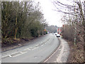
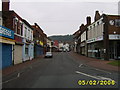
Holyhead Road, Oakengates
The Holyhead Road (old A5) looking West. This is the line of Thomas Telford's great road from London to Holyhead. Now superseded by the M54 motorway. Click for another view looking East Image
Image: © Gordon Cragg
Taken: 14 Feb 2009
0.06 miles
4
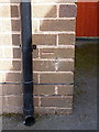
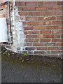
OS benchmark - Oakengates, 15 Church St
An OS cutmark on the front face of no 15 Church Street; originally levelled in 1985 at 127.079m above Ordnance Datum Newlyn.
Image: © Richard Law
Taken: 5 Jul 2014
0.07 miles
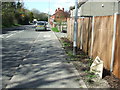
5
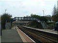
Oakengates Railway Station
The station is still open, but few trains stop here anymore.
Image: © Steve McShane
Taken: 15 Apr 2006
0.07 miles
6
OS benchmark - Ketley Bank/Oakengates, 48 Holyhead Road
An OS cutmark on the side wall of the building (facing into Church Street, rather than the old A5 Holyhead Road); originally levelled in 1960 at 137.962m above Ordnance Datum Newlyn
Image: © Richard Law
Taken: 21 Feb 2015
0.07 miles
7
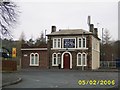
Oakengates Railway Station
No longer used as a station it is now a dental practice
Image: © Mr M Evison
Taken: 5 Feb 2006
0.07 miles
9

Centre Point, SJ6910
Right on the centre point of SJ6910 is "The Depot". Not, as you may think, a tyre and battery centre but a dance studio. I expect they can do wonders for any spare tyres.
Image: © Gordon Cragg
Taken: 14 Feb 2009
0.07 miles
10
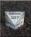
Old Milepost by the B5061, Holyhead Road, Oakengates
Cast iron post by the B5061 (was A5), in parish of WROCKWARDINE (TELFORD AND WREKIN District), Holyhead Road; Oakengates, between junction of Station Fields and No. 40 in hedgerow, on East side of road. Erected by the Watling Street, Wellington District turnpike trust in the 19th century.
Inscription reads:-
: SHIFNAL / 4 : : LONDON / 137 : : SALOP / 13M 6FUR :
Shropshire HER listed.
HER Number (PRN): 21093 https://www.heritagegateway.org.uk/Gateway/Results_Single.aspx?uid=MSA23663&resourceID=1015
Milestone Society National ID: SA_SFSB04.
Image: © A Reade/M Faherty
Taken: 10 Feb 2008
0.07 miles