IMAGES TAKEN NEAR TO
Lion Street, TELFORD, TF2 6AF
Introduction
This page details the photographs taken nearby to Lion Street, TF2 6AF by members of the Geograph project.
The Geograph project started in 2005 with the aim of publishing, organising and preserving representative images for every square kilometre of Great Britain, Ireland and the Isle of Man.

There are currently over 7.5m images from over14,400 individuals and you can help contribute to the project by visiting https://www.geograph.org.uk
Image Map
Images are licensed for reuse under creativecommons.org/licenses/by-sa/2.0
Notes
- Clicking on the map will re-center to the selected point.
- The higher the marker number, the further away the image location is from the centre of the postcode.
Image Listing (304 Images Found)
Images are licensed for reuse under creativecommons.org/licenses/by-sa/2.0
Image
Details
Distance
1
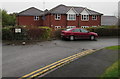
Station Mews, Oakengates, Telford
Housing about 70 metres from the entrance http://www.geograph.org.uk/photo/4736059 to Oakengates railway station.
Image: © Jaggery
Taken: 9 Nov 2015
0.01 miles
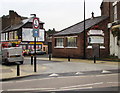
2
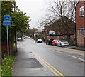
End of cycle route - cyclists dismount, Oakengates, Telford
The white on blue signs are alongside Lion Street.
Image: © Jaggery
Taken: 9 Nov 2015
0.01 miles
3
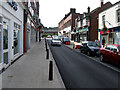
Oakengates Regeneration Project
The Oakengates Regeneration Project has now entered its final stage, the roads have been reopened to traffic and the main focus is now on landscaping the area.
Oxford St. is finished and the traffic flow has reverted to its final direction (South to North). Photo looking South. 8th Sept 2012.
Image: © Gordon Cragg
Taken: 8 Sep 2012
0.02 miles
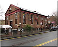
4

Former Co-op central premises, Oakengates, Telford
The inscription on the corner of Oxford Street and Lion Street records that the building
was formerly Oakengates & District Co-operative Society Limited's central premises.
Image: © Jaggery
Taken: 9 Nov 2015
0.02 miles
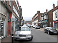
5
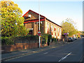
Oakengates, Shropshire: Lion Street
This substantial building on Lion Street seems to have had a number of short-term uses. But what was it originally?
Image: © Dr Neil Clifton
Taken: 1 Nov 2011
0.02 miles
6
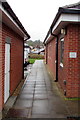
Use path at your own risk, Oakengates
The path between Salvation Army buildings gives walkers a short cut
from Oakengates railway station to Lion Street. The notice on the right shows
YOU ARE WELCOME TO USE THIS PATH BUT DO SO AT YOUR OWN RISK.
Image: © Jaggery
Taken: 9 Nov 2015
0.02 miles
7
The Tread Shed and Station Garage, Oakengates, Telford
Tyre retailer and motor factor on the corner of Oxford Street and Lion Street.
Image: © Jaggery
Taken: 9 Nov 2015
0.03 miles
8
Oxford Street, Oakengates (Recreated Friths)
Oxford Street, Oakengates, looking South towards the railway station. Little change to the buildings since 1965 but it is noticeable that the vehicles stayed on the road and not all over the pavements. Of course at that time police officers were often on patrol on foot, unlike to-day. Compare with Frith's photo from 1965. http://www.francisfrith.com/search/england/shropshire/oakengates/photos/oakengates_O1041.htm Another view looking North here.Image
Image: © Gordon Cragg
Taken: 23 Feb 2009
0.03 miles
9
Industry nightclub, Oakengates, Telford
Viewed across Lion Street.
Image: © Jaggery
Taken: 9 Nov 2015
0.03 miles
10

South side of Salvation Army premises, Oakengates
This side is opposite Oakengates railway station. The road side of the building faces Lion Street.
Image: © Jaggery
Taken: 9 Nov 2015
0.03 miles